 |
| At DOCK in EAST TAWAS STATE DOCK |
We got up and got started early Monday morning. And it was cool, 50F. I started out in jeans and a windbreaker. And then we had to wait for the fuel dock, as there was only one employee until 9. There were two boats there, and a third one pulled in before we could get there. So we got fuel, took on some water in the tank, and were off towards Alpena. It was a good trip until the last hour. We got to Alpena, about 60 miles, a little after 3. The wind was kicking up pretty good (20kt?) as we entered the harbor. The "Sav-A-Lot" grocery store was across the road from the marina, and a 1/2 block walk. We re-stocked on the items depleted: sandwich meat, milk, cereal, meat, bread, vegetables, and some chips. We went back to the boat, cooked dinner, and then pulled our wagon of dirty clothes to the laundromat, which was across the parking lot from the grocery store. I did not walk the two blocks to check out the ice cream shop, hard as that sounds to believe. Though this was a regular, and large laundromat, and we used multiple machines, it was still late when we got back to SummerTime. Alpena is the home of Thunder Bay National Marine Sanctuary. There are a lot of wrecks out in the bay, and along the isthmus going to Presque Isle. We did not visit the facility, but saw the buoys for the divers to moor to. They have a special symbol on the chart for the dive buoys, which was new to me.
We got up early on Tuesday, and got moving before the dock boy arrived. This is a joint run marina. The state has it in their "Harbors" program, it is owned by the city/village, and they contract a marine service company to run it. The facilities were average, and much better than Grand Bends, On. Barb stated only one bulb was working in the women's rest/shower room. The winds were reported at 10mph from the South and SW, depending on the station/buoy. They helped to push us along towards Presque Isle, where we planned to anchor for the night. We got to Presque Isle a little before 1, and decided to continue on.
 |
| PRESQUE ISLE LIGHT, ONE of MANY WE SEE |
We moved the last turn in the GPS towards Calcite, just before Rogers City, where there was a bay that looked good for anchoring. We got there a little after 2, and dropped the hook. We drifted the first time, so we pulled the anchor, moved, and put the hook out again. This time it set, as we changed the procedure slightly to set it. The water was extremely clear. You could see the bottom in 18' deep water. There was white sand, and dark spots that came up as clay on the anchor. The winds shifted, and I was beginning to question the decision to anchor in a 3 sided bay with Rogers City so close. But tieing up to a dock every night gets to be expensive. The ratio for anchoring/ tieing is as we have been doing is the reverse of what I budgeted when I planned the trip. About an hour before sunset, the winds died and everything became peaceful, and less nerve racking. Barbara sat on the flybridge and watched the sunset. It was a nice peaceful night at anchor, what you anchor out for.
I woke early and started to look at my phone for the weather. I got Barbara up, and told her if we got going, we might make Cheboyagan by mid day. Which would put us less than half a day from Mackinaw. The winds had shifted to the south again, and picked up speed before we could weigh anchor. They pushed us mightily, and sometimes we hit over ten knots of speed as we surfed don the face of waves w. That was good as the engine speed was set to where we normally would be getting 8.8 kt. But getting to Cheboygan was not to be. The clouds started to form, and 2/3 the way through our long leg, we got sprinkles. and it was cool. I started to look at the alternate harbor of "Hammond Bay, a Harbor of Refuge". And that is what it became this day. We both saw the same lightning flash over the land, and we immediately re-plotted our course towards Hammond Bay. Today we were going to use Michigan's Harbor of Refuge. We got into the harbor a little after 10:30. It is raining pretty good as we tie up. The harbor master came out to help us dock, even though it was raining mightily at times. I think that he was bored. There is only a sailboat in the harbor besides us. We check in, and decide to stay here, as the weather does not look good for the rest of the day. But we have traveled 3 days straight now.
 |
| HAMMOND BAY, a MICHIGAN HARBOR of REFUGE |
 |
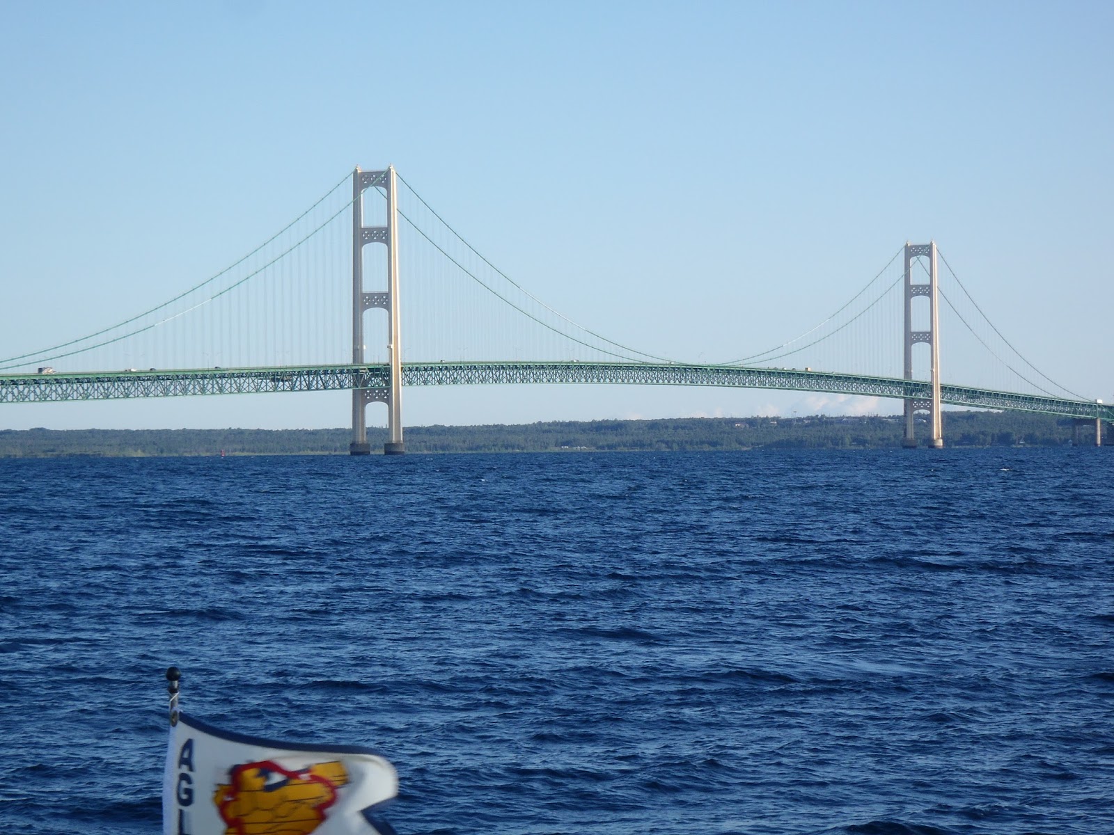
| MACKINAC BRIDGE in BACKGROUND at 12 MILES OUT |
As we get closer, the bridge starts to dominate the horizon. And as we pass Mackinac Island, you can see the famous hotel up against the side of the hill. It dominates the island view. And there are ferry boats constantly crossing both ways between Mackinaw City and Mackinac Island. We will have to be careful when we get into the traffic area. We contact the Straits State Marina about 12:45 and ask to go to the fuel dock. We have been 4 days without fueling, and our water tank is getting low also. We take on 114 gallons of fuel, the most I have ever put in the 190gal tank. And our friend is still on the burgee mast. He is a praying mantis, and moves off as we pull around to our slip.
 |
| OUR STOWAWAY FOR 40 MILES |
We woke up Friday morning, listened to the weather while eating cereal for breakfast (Barb would pay for this later), and decided it was the best window we were going to have for several days to head to the eastern shore of Lake Michigan. We were underway the earliest yet at about 8:10am. We are getting better at this. The weather report was for winds out of the west at 8-10mph with waves "less than 2ft." By the time we had gone the two miles to pass under the bridge, we were seeing seas of 3ft. Not too much for us or SummerTime, so we kept moving. Another trawler passed under the bridge right in front of us.
  |
| MACKINAC BRIDGE ABOUT a MILE OUT |
We have a long haul, about 20mi to get to the point where we can turn south along Lake Michigan's eastern shore to see the other coast of Michigan. About half way to our turning point, the winds pick up and the seas increase. They are now running 3-5'. NOAA has not changed their weather report, nor has the data from the buoys changed. I think that they need to re-calibrate the telemetry on their buoys. We get to the point where Lake Michigan is running north-south, and make our turn to follow the coast. We glide by an abandoned light house on a shoal of about 20' depth. There are several light houses out here in N Lake Michigan marking shoals.
 |
| ABANDONED LIGHT HOUSE |
I do not think that having to man one of these many years ago would have been a pleasant job. Nor bringing supplies to one like this before helicopters. We have a long run down the west shore of Michigan. It seems to get a little calmer, and as Barbara goes to make sandwiches for lunch, the winds and waves increase. She says the milk she had with her cereal has been churned into butter. She only brings one sandwich up to the flybridge. But we are headed south, which is the next milestone for us. We will get to Petoskey, Mi. on Little Traverse Bay about 2:30. We are also crossing some deep water. At over 270ft, it is deeper than any I have operated a boat in, including out in the Atlantic growing up.
 |
| 272ft and WE ARE ONLY ABOUT a MILE OFFSHORE |
The depth is not as impressive as the drop off. And then, Michigan is quiet hilly along in here. We are passing by sandy beaches with really nice houses above them.

It gets rougher as we get near Petoskey, and make the turn down Little Traverse Bay. It is a lovely little town at the end of the bay, with a beautiful clock down by the water. We are going to take a day of rest here as the rains are forecast again for Saturday.
 |
| APPROACHING PETOSKEY TOWN DOCK |
No comments:
Post a Comment