We got onto the C& D Canal on 7Sep. We spent the weekend hunkered down, anchored in the basin at Chesapeake City riding out the winds and rains of tropical depression Gordon as it went across the NE. On Monday we moved down the bay getting as far as Rock Hall. The weather forecast was not good, so we planned to go to Rock Hall with Worton Creek as an alternate bailout location if the bay was too rough when we got to the open areas. It was not that bad, so we made Rock Hall easy. Probably could have gone farther. We tried to find a place to put SummerTime on the hard in the Hampton Roads area, but struck out. Tuesday morninng we got up to dense fog. So much for getting to the Severn River by Wednesday evening as a possible place to take SummerTime out of the water on Thursday. We checked locally, and took SummerTime from Rock Hall to Lippincott Marina in Grasonville, MD. All of 14 miles. SummerTime will sit on the hill here until the Atlantic settles down with hurricane breeding. We are going to SE Virginia.
Our relatives in coastal NC need prayers, as will everyone in that area. We do not think Barbara's brother will leave Carolina Beach. But a cat 4 classification on Florence may change his mind. Barbara's older sister will stay in her house as it is high. My younger sister & her husband are going farther inland to stay with friends in their brick house. My other sister is struggling. She is just getting back in her trailer after Irene flooded it in 2011.
At any rate, Barbara and I are safe. We will start our blog back up after we resume our journey, most likely early October.
Rodney
Tuesday, September 11, 2018
Saturday, September 8, 2018
Little Triangle Loop, Week #10, 25-31Aug018, NYC AND CONNECTICUTT
We are not in much of a hurry to get out of this marina this morning. It is low tide when I get up, and I well remember the problems we had getting in to Cornetta's Marina and Restaurant in Piermont. We are ready and get underway about 10. The tide is about 3/4 way up now. We back out of the slip easily versus the dragging we did going in this past Friday. I had watched other boats going out this morning, and change my route out to parallel the pier, and stay closer than what the charts would imply you should do. The water appears to be 1-2' deeper this way, even given the tide difference. After we clear the end of the dike or "Pier", we slowly pick up to cruising speed. We come to one of New Jersey's State Marinas and I call them on the radio. They do not answer until I get in front of the opening of their bulkhead. The attendant states their depth is only about 2' at the service dock. We proceed farther down the river. We are in front of the NJ Palisades in this section of the Hudson River, but NY City can be seen in the curve beyond them.
Most of the traffic this morning is fisherman and high speed boats headed, I presume, to the city. About 10 miles past the first New Jersey marina, we come to the second one, Edgewood, and they can take us in. We get a pump out and then top the fuel tank off. An hour later we are headed up what is called the "East River" through New York City. The current is falling out of the river and I have to run at 85% power to make 5-7kt, or about half the normal speeds for this given rpm. If we had thought the traffic around the Statue of Liberty was bad, this is twice as bad.
There are more water taxis with more docks to pull up to, the same big sight seeing boats, dinner cruises, and of course the pleasure craft transiting through. We pass one sail boat, and I am thinking that he is going full power to make 1-2 knots against this current. This "River" has a reputation, and passing through it is recommended only on slack tides. It even has an area where the Harlem River breaks off, where the reputation is bad enough that the name is "Hell Gate" for this curvy intersection. It takes over an hour and a half to get to Rikers Island where the current has decreased to about half what it was. The current has not really slowed, the river is just twice as wide here to pass the same volume of water. In another 30 minutes we have passed La Guardia Airport, and are at Worlds Fair Marina. There are actually two docking areas here, and they put transient boaters in the first one which is being rehabilitated. The dock master comes from the other location and gets us checked in.
We are across the Interstate from CITIField where the Mets play. We need to do laundry, so I go to the site of the other marina to check out the laundry. It is 3/4 mile away, with one washer and one dryer. The only consolation is that they are free. Back at the boat, I get our collapsible wagon out, as we decide to postpone dinner and get laundry done first. We do the most critical things, underwear, shorts for me, lightweight shirts for both of us. It is well after dark when we get back to SummerTime. Barbara fixes a quick dinner, and we both retire. The clean clothes can wait to be put away.
This Sunday we will not get to a church. I had "Googled" "churches near me", and the closest one was nearly a mile away. Walking that will mean more like a mile and a quarter at least. I have learned that "Googles" first distance measurement is "as the crow flies". When you actually ask for the directions, then you learn that there a few twists and turns in the route, making it longer than the search stated. About 12:30 we head over to CITIField to see the NY Mets play the Washington Nationals. We are in our seats well before the 1:10 game start, even though the walk off of the pier is 1/4 mile. Lunch is a ball park hot dog, "Nathans" in this case. The first 6 innings are slow, and then the Nationals, who have been dominated by the Mets up to this moment, wake up. At the end of 9 innings, the Nationals win 15 to 0. We retired to SummerTime to rest for Monday's journey. We have decided we have some time before we have to be back in Hampton. We are going to go into Long Island Sound and do some touring.
Monday morning we secure everything and head out from Worlds Fair Marina. We follow a tug out of the channel thinking that he will guide us through the rocky areas on the charts. This plan works to just before the last bridge before the sound. The tug is pushing an empty barge, and moves out of the main channel over to an anchorage to tie this barge to another empty one that is staged in the anchorage.
So much for that plan, as the rocky area is just ahead at the beginning of the sound. We proceed on into the sound with the route I had input into the chart plotter earlier in the morning. We are headed to Norwalk, CT. There is an old town shopping area there as well as an aquarium. There is little wind on the sound, so our ride is smooth. There is no commercial traffic, but a lot of fast pleasure craft and sail boats. There is also a lot of fishermen on the sound trying to catch fish.
We are pretty close to being in the middle of Long Island Sound so there is not a lot sightseeing. You can see both sides, as the sound is narrow in this lower part, but not see the shores good enough to sight see. As we near Norwalk, we start to see some big boats commercial fishing. There are a number of islands off of Norwalk, and the first one has a lighthouse on it. It is easy to tell you have come to the right spot with landmarks like that to navigate to. We follow the channel on up to Norwalk Cove Marina, just inside and off of the mouth of the river. The dock hand meets us and helps us tie up in our assigned slip. It is warm and we visit the marina store as we wait for SummerTime to cool. After dinner, Barbara does the laundry she could not do with the 1 machine restriction at Worlds Fair Marina.
Tuesday we take advantage of the Marina's shuttle to the business district of South Norwalk (SoNo). The driver drops us at the Post Office, we mail our documents, and then walk the street back to the aquarium. It is a nice aquarium, geared mainly on local salt water life. They do have some harbor seals swimming in a pool, as they are a native species here in the winter.
I am disappointed to read the seals are only here from September to March. The guide book stated you could see them around the Sheffield Islands so I was planning to see them going out by the Islands leaving Norwalk. This aquarium also has a lot of jellyfish, and many species. I learn more about different species of jellyfish, and their lives, than I ever thought was possible. I thought they were a colony of one cell animals that sting people. They do not have a brain, but they do understand their environment and how to work together to survive in it. The Norwalk aquarium has been studying jellyfish since before the turn of the century, and they actually breed and sell jellys to other aquariums. We leave the aquarium to go get lunch at a Mexican Restaurant across the street. The menu is not the typical taco and burrito fare, and the unique dishes are very tasty. We hurry back to the Aquarium as it has an Imax theatre and entry to one show was part of our admission. We watch a documentary on "Great White Sharks". Why not, we are closer to Amityville than we have ever been before. After the film, we go to the downtown area to check out the shops. We walk on two streets, but do not see anything that interests us. We go to C-town grocery and pick up some items for the coming week. We call the marina for our return shuttle ride.
On Wednesday morning we have to make a decision. I originally wished to go at least to Mystic Seaport, another day and a half at SummerTime's cruise speed. Thursday is the last day weather wise in the coming week to make the trip from NY harbor to Manasquan, NJ. This stretch has to be done in the Atlantic Ocean, there are no sheltered passages. The forecast is for this coming Friday to the Tuesday after Labor Day to be high winds and some rainy days. If we proceed to Mystic, and the weather stays bad, we could be stuck in Long Island Sound area until another weather window opens up. If we leave today (Wednesday) we can get to Sandy Hook, and be ready to do the Atlantic travel on Thursday in relatively calm conditions. We decide to turn back towards the good weather crossing. We will have to see Mystic by car on another day. We depart Norwalk Cove Marina, and go out between some of the Sheffield Islands. We pass by commercial fishing boats dredging for oysters. Oysters are one of the resources that made Norwalk prominent along the Connecticut coast. This boat has what looks like a small mountain of oysters on the fore deck.
When I ate oysters a lot, I do not think I could have eaten as many in a lifetime as i see on the deck of that one boat. After getting outside the islands, we head SummerTime towards the East River entrance off Long Island Sound. We meet a ship, which surprises me to some extinct. It is a small freighter, probably carrying freight to some smaller New England port from NYC.
I should not be surprised, as the LI Sound is suited for vessels like this to travel in. We get to the East River, pass by La Guardia Airport, and the tide is falling. Today we will be traveling with this strong, swift current. There is a lot less traffic today on this route through the City. The water taxis are all still rushing around, but a lot of the excursion and personal boats are gone.
We hit NY Harbor much quicker than leaving it this past Saturday. As we turn south down the Hudson, a car transport ship pulls away from the dock in NJ. They are easily recognized as they have tall slab sides, and a heavy ramp folded flat against the stern of the ship. It is headed to the open ocean for a crossing. They sit high out of the water all the time, so you do not know if they are empty or loaded. When you see one of these car transporters coming into this country, you know they are most likely loaded. When they are leaving, you do not know if they are empty, as there are some vehicles shipped from the US to other countries.
After this transporter gets under the Verrazano Narrows Bridge, he picks up speed. We continue on to the south to Raritan Bay at Sandy Hook. We are plotted into the marina at Atlantic Highlands, NJ. We are careful on entry as the US Navy has a pier extending way out into the bay. We take care not to encroach on their space. Atlantic Highlands told us when we made reservations we would be at a fixed dock. It did not prepare us for what we got. The pier itself is substantial, but the height is way more than we have had in past partially due to the 6' tide range. Also, a lot of piers after Hurricane Sandy were rebuilt higher. Sandy came in on high tides, and the storm surge caused a lot of damage due to boats being above the piers they were moored to. At any rate, there is a ladder there that we use to get off and on SummerTime's deck.
We eat on board, though there is a nice little developed downtown area by the waterfront. After dinner we walk along the wide walkway to the downtown area. There is a new creamery with reviews boasting good their ice cream is. It is bout a 1/2 mile walk, but worth it. I get a mocha with chocolate bits in it on a waffle cone. I do not think the flavor I get is any better than Stewart's Brew Ha Ha, but their homemade waffle cone is very tasty. We walk back to SummerTime on the other side of the street to check out the other restaurants and antique/art/gift/souvenir shops that seem to be in all these little town waterfronts.
Thursday morning the weather is nice as forecast. We get away from Atlantic Highlands and go the short route to the point at Sandy Hook. We pass by the CG station where there small boats are, and there is one of the bigger 80' boats anchored just a short distance from the station. On the point of land that separates Raritan Bay from the Atlantic Ocean. There are boats next to the breakers on this point fishing as well as people up on the beach casting into the surf.
After we clear the point, I put SummerTime on the initial heading parallel to the beach to get us back to our re-entry point at Manasquan Inlet, NJ. We ride along about 2-3 miles off shore, enough to be in good water depths, but still able to sight see what is on the shore. Off the beaches between Sea Bright and Belmar, NJ, I see a sight I have never seen from one our own boats in all of my years of boating. The small bait fish are all balled up in several groups. At one of the farther groups I see what I am pretty sure is a whale feeding on them. I yell for Barbara to get the camera. She does, and manages to get several pictures as it surfaces while feeding and breathing.
We do not try to get too close as Federal laws regulate how close one can get to marine mammals, in particular whales. We discuss this sighting, and think it may be either a minke or finback. We saw both on a whale watching trip in Nova Scotia several years prior. We learned on the Nova Scotia trip that photographing whales is very hard. They disappear, you do not know where they are going to come up, when they do surface it is only for seconds, and they are gone again to come up who knows where. The best way to capture one in pictures is to use video. We can not do that today as I did not clear the card on the camera with the video feature. The rest of the outside passage to Manasquan Inlet is kind of anti-climatic. We enter the inlet with several fishing boats and one crew vessel from an offshore dredge. One boat is in a hurry and passes several boats moving slowly in the confined channel of the inlet. When we get the approximately 1 mile in, this bigger boat is waiting like everyone else, but in the middle of the channel. Even the crew boat captain is unsure of how to approach him. While everyone is milling about trying to see what this big boat is going to do next, the railroad bridge closes to boat traffic. This is a tough inlet to be coming in on a boat. There is a railroad bridge which serves the NYC-NJ commuter trains so that the bridge closes to boat traffic every so often. There is a warning siren, and down it goes.
It is scheduled train service, so boats that transit the inlet daily can make their transits around the train schedules. About a quarter mile after the R/R bridge is a highway bridge which has to be opened for any traffic taller than 30', which is all sail boats and fisherman with tuna towers. We go down the Pleasant Point Canal into Barnegat Bay. We go slow in Barnegat Bay as it is shallow but even at our slow speed we get to the Toms River Marina well before the closing time. We stop in at the main dock at Lighthouse Point marina for a slip assignment, and then move to the dock they have assigned us to. This is a nice marina with plenty of resident boaters. It reminds me of Brands Marina where we kept SummerTime for 3 years while living in Ohio. We are told that there are restaurants close by, and "Google Maps" shows that there are. One of the regular boaters here comes over as we walk off SummerTime. He introduces himself as Luis, and notes that our boat is from Carolina Beach near where his "new to him" boat came from. He also inquires if we are doing "The Great Loop" as he has another boating friend interested in it. We converse a few minutes, then we walk to Rocco's pizza for dinner, and end up getting a box to bring part of our pizza back to the boat. We also walk to "Sundaes" two doors down and get an ice cream. They have no inside eating area, so we sit outside on a bench and hurry our eating so we can consume our ice cream before it melts.
Friday finds us doing small things on the boat. I try to arrange a car rental so we can go visit our niece who lives a little over an hour away in western NJ. I have no luck, and am surprised that the rental car companies locally have no vehicles available. We call our niece and cancel our planned Saturday trip to her home. This also throws a kink in our plans to provision SummerTime. Barbara and I check "Google Maps" for groceries or Convenience stores nearby. There are no grocery stores, but there are other sources for small grocery items nearby. We walk out to Dicky's Dogs for lunch, which is only 450ft away walking per Google. This confirms what I have always thought, that the original directions you get from "Google" are "as the crow flies". We can not walk across the canal to get to Dicky's, so we walk the 1/4 mile around by land. From there we walk on to the other business area farther down the street. There is a Rite-Aid here where we can buy milk and bread. Also there is "Two Sisters" ice cream parlor just past the Rite-Aid. They make their on ice creams, and buy their sherbets and ices. Barbara gets peach ice cream, which totally surprises me. She always gets the strongest chocolate flavor available. But the one sister running the place says it is their last fresh peaches, and it will be the last batch of peach they make for the year. Barbara is persuaded. I sample the cherries in chocolate ice cream, but the chocolate is too strong, overpowering the cherries. I get a chocolate covered cherries in vanilla dipped into a waffle cone. We get our few grocery items at the Rite Aid and walk back to SummerTime. For the rest of the day we pretty much spend our time in the AC of the boat.
 |
| NEW JERSEY PALISADES |
 |
| TRAFFIC IN EAST RIVER |
 |
| CITIFIELD BEYOND THE MARINA |
This Sunday we will not get to a church. I had "Googled" "churches near me", and the closest one was nearly a mile away. Walking that will mean more like a mile and a quarter at least. I have learned that "Googles" first distance measurement is "as the crow flies". When you actually ask for the directions, then you learn that there a few twists and turns in the route, making it longer than the search stated. About 12:30 we head over to CITIField to see the NY Mets play the Washington Nationals. We are in our seats well before the 1:10 game start, even though the walk off of the pier is 1/4 mile. Lunch is a ball park hot dog, "Nathans" in this case. The first 6 innings are slow, and then the Nationals, who have been dominated by the Mets up to this moment, wake up. At the end of 9 innings, the Nationals win 15 to 0. We retired to SummerTime to rest for Monday's journey. We have decided we have some time before we have to be back in Hampton. We are going to go into Long Island Sound and do some touring.
Monday morning we secure everything and head out from Worlds Fair Marina. We follow a tug out of the channel thinking that he will guide us through the rocky areas on the charts. This plan works to just before the last bridge before the sound. The tug is pushing an empty barge, and moves out of the main channel over to an anchorage to tie this barge to another empty one that is staged in the anchorage.
 |
| PARKING ONE BARGE TO ANOTHER, 2 CREW IS READY ON DECK OF BARGE W/ TUG |
 |
| DIFFERENT BOATS FOR FISHING IN LI SOUND |
Tuesday we take advantage of the Marina's shuttle to the business district of South Norwalk (SoNo). The driver drops us at the Post Office, we mail our documents, and then walk the street back to the aquarium. It is a nice aquarium, geared mainly on local salt water life. They do have some harbor seals swimming in a pool, as they are a native species here in the winter.
 |
| HARBOR SEALS IN AQUARIUM POOL |
On Wednesday morning we have to make a decision. I originally wished to go at least to Mystic Seaport, another day and a half at SummerTime's cruise speed. Thursday is the last day weather wise in the coming week to make the trip from NY harbor to Manasquan, NJ. This stretch has to be done in the Atlantic Ocean, there are no sheltered passages. The forecast is for this coming Friday to the Tuesday after Labor Day to be high winds and some rainy days. If we proceed to Mystic, and the weather stays bad, we could be stuck in Long Island Sound area until another weather window opens up. If we leave today (Wednesday) we can get to Sandy Hook, and be ready to do the Atlantic travel on Thursday in relatively calm conditions. We decide to turn back towards the good weather crossing. We will have to see Mystic by car on another day. We depart Norwalk Cove Marina, and go out between some of the Sheffield Islands. We pass by commercial fishing boats dredging for oysters. Oysters are one of the resources that made Norwalk prominent along the Connecticut coast. This boat has what looks like a small mountain of oysters on the fore deck.
 |
| OYSTERS BEING DREDGED FROM THEIR GARDENS |
 |
| SMALL FREIGHTER ON LONG ISLAND SOUND |
 |
| WATER TAXIS |
 |
| CAR CARRIER PASSING OUT TO SEA UNDER VERRAZANO NARROWS BRIDGE |
 |
| HIGH FIXED DOCKS AT ATLANTIC HIGHLANDS MARINA |
Thursday morning the weather is nice as forecast. We get away from Atlantic Highlands and go the short route to the point at Sandy Hook. We pass by the CG station where there small boats are, and there is one of the bigger 80' boats anchored just a short distance from the station. On the point of land that separates Raritan Bay from the Atlantic Ocean. There are boats next to the breakers on this point fishing as well as people up on the beach casting into the surf.
 |
| FISHERMAN & BOATS ON SANDY HOOK |
 |
| WHALE FEEDING OFF NJ COAST (bottom left in photo) |
 |
| COMMUTER TRAIN NJ to NY CITY, DRAWBRIDGE BEYOND |
Friday finds us doing small things on the boat. I try to arrange a car rental so we can go visit our niece who lives a little over an hour away in western NJ. I have no luck, and am surprised that the rental car companies locally have no vehicles available. We call our niece and cancel our planned Saturday trip to her home. This also throws a kink in our plans to provision SummerTime. Barbara and I check "Google Maps" for groceries or Convenience stores nearby. There are no grocery stores, but there are other sources for small grocery items nearby. We walk out to Dicky's Dogs for lunch, which is only 450ft away walking per Google. This confirms what I have always thought, that the original directions you get from "Google" are "as the crow flies". We can not walk across the canal to get to Dicky's, so we walk the 1/4 mile around by land. From there we walk on to the other business area farther down the street. There is a Rite-Aid here where we can buy milk and bread. Also there is "Two Sisters" ice cream parlor just past the Rite-Aid. They make their on ice creams, and buy their sherbets and ices. Barbara gets peach ice cream, which totally surprises me. She always gets the strongest chocolate flavor available. But the one sister running the place says it is their last fresh peaches, and it will be the last batch of peach they make for the year. Barbara is persuaded. I sample the cherries in chocolate ice cream, but the chocolate is too strong, overpowering the cherries. I get a chocolate covered cherries in vanilla dipped into a waffle cone. We get our few grocery items at the Rite Aid and walk back to SummerTime. For the rest of the day we pretty much spend our time in the AC of the boat.
Sunday, September 2, 2018
Little Triangle Loop, Week #9, 18-24Aug018, SLOW TOURING ON THE HUDSON
We spend Saturday trying to do some chores. It has showered some when we get up, and is going to shower more. We move SummerTime over to the fuel dock and get the holding tank pumped out. The water tank is near empty, the boat lists to starboard, so the pump out connection on the bottom starboard end of the holding tank is the low point of the tank. Then we fill the water tank so that the boat lists to the port (left). This puts the fuel tank vent on the high side (starboard now) of the boat, and we are able to fill the fuel tank. We just get the fuel tank filled when the bottom falls out of the sky. We wait for about 30 minutes before we can move SummerTime back to her slip. In the late afternoon the sky finally starts to clear. I re-organize our charts and guide books. Putting the ones not needed any longer back in their storage area, and getting back out the ones for the Hudson River and south. On Sunday we get up and use the courtesy car to go to church, sort of. We are getting dressed when Jim of Ping (arrived at Shady Harbor on Friday) arrives knocking on our hull. He asks if he can drop us and pick us up from church with the courtesy car. They wish to use the courtesy car in the same time. I think that this is a good option for all, so I agree. We meet Jim by the courtesy car at the appointed time, and he drives us to The New Baltimore Reformed Church. It is the same church we attended 5 weeks earlier, and the pastor and congregation remember us. Jim is there to pick us up promptly when church is over. We get back to SummerTime and prepare to leave to Saugerties, NY.
The guides only have two marinas for Saugerties. We have not been able to get in touch with one for a slip reservation, but decide to leave anyway. We can always find a cove to anchor in. Part way down the River to Saugerties, one of the marinas finally returns our phone call. We make arrangements for a slip for two nights, though the marina operator warns us that a lot of debris is coming down the Saugerties River from the recent rains.
We are aware of the debris he is talking about as we have seen several trees and branches coming down the Hudson in the short time we have been on it. After about 3 hours we have the Saugerties Light in sight. It is privately owned, has been restored, and is currently operating as a Bed & Breakfast, so it looks very good.
Our dock at Saugerties Marina requires careful tie-ing of our lines as the river current is swift. The marina owner is very good and offers to drive us downtown to "Miss Lucy's Kitchen". It has good reviews in the guide books, and we wish to try it out. It is one of the reasons we chose Saugerties to stop at going back down the Hudson. The food and service at Miss Lucy's does not disappoint us. The food is labeled Comfort in the guide, but it is done as "New Eclectic" and very tasteful. The restaurant is an old building in downtown. Saugerties has one of the first registered "National Historic Business Districts".
Also there is a number of art sculptures decorated and on display in the business district. They are similar sailing boats that businesses have artfully decorated and placed in front of their establishment. We catch a taxi back to SummerTime. Stagecoach Taxi only charges $5.00 for local rides.
On Monday, we call Stagecoach and get a taxi ride back to the heart of the village. We saw a number of interesting shops while in the village for dinner on Sunday night and wish to go back and visit some of them. We have lunch at Dallas's Hot Wieners. Their hot dogs are very good, and inexpensive. My father would have loved their dogs, as the rolls are steamed, his preference. They also make their own meat chili to go on them, very tasty. There are a number of specialty stores and antique stores we browse through. One book store has a very quaint coffee shop in one corner, with a very mixed selection of books. The "Second Best Ice Cream Shop" in NY is here, but we do not get any ice cream here on this day. They are only open Wednesday through Sunday. We do get a cone at another ice cream shop nearby. There are 3 ice cream shops in the same block. On our walk out of town we stop at Krause's Chocolates. Krause's is our other reason for visiting Saugerties. They have been hand dipping chocolates since 1929. We have some gifts for others and chocolates for us. We have a light dinner back on SummerTime and discuss plans for the week.
On Tuesday we leave Saugerties headed for Poughkeepsie, New York. We made a reservation on Monday for a Wednesday lunch at "The Culinary Institute of America". The ride down the Hudson to Poughkeepsie is almost as impressive as going down Lake Champlain. The Catskills come almost down to the river's edge at some points. There are a number of interesting little towns along the way, but we pass through them all, albeit at a slower pace than in the past.
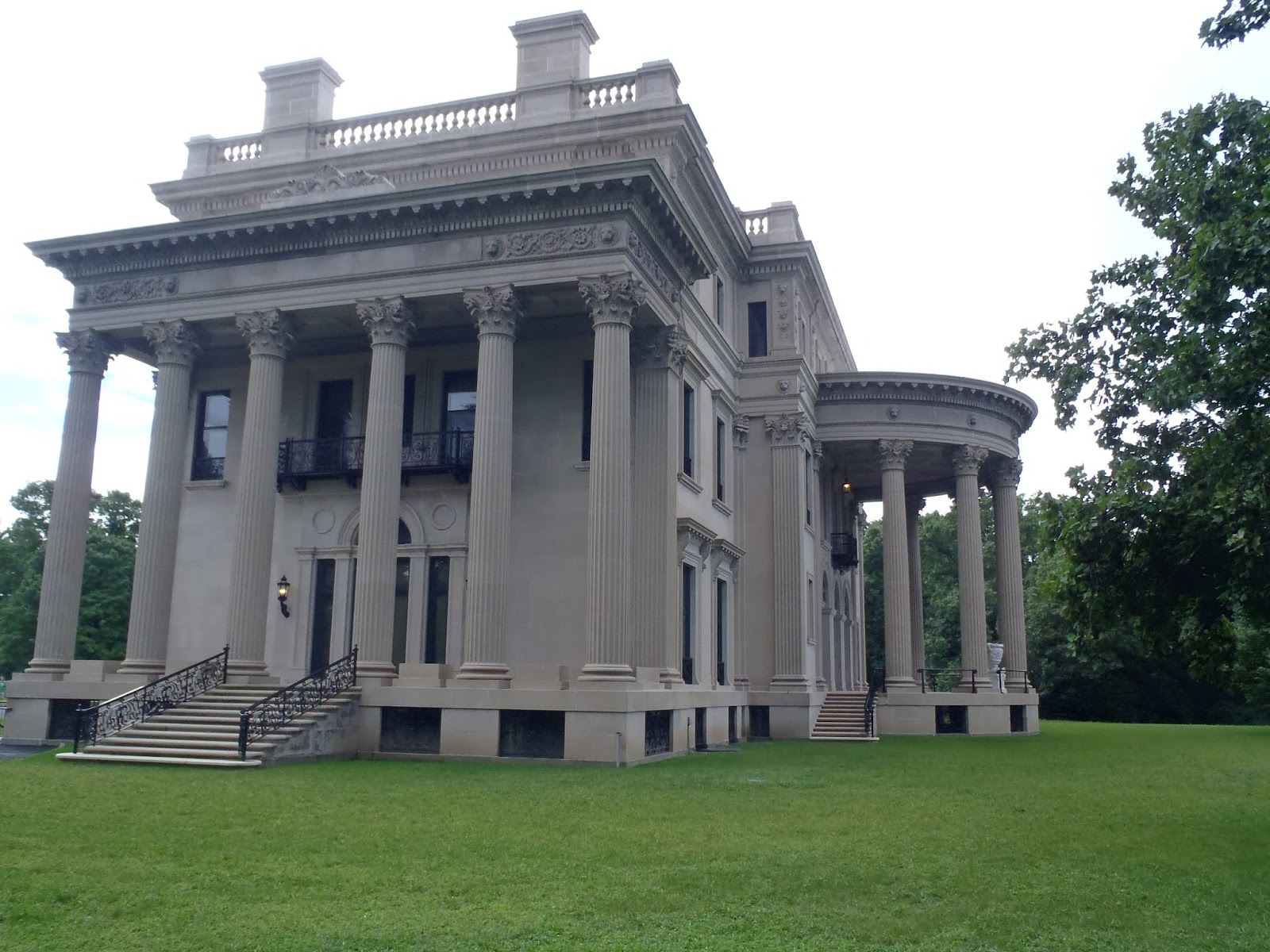
We get to Poughkeepsie in the middle of the afternoon. We are met right before the River Pedestrian Crossover bridge by a NY State EnCon boat. They ask to board and do a safety inspection. We oblige, and after Barbara gives the officer about a 5 min tour of what he wishes to check, we are released to continue on our way. In 5 more minutes we are at our dock at Shadows Marina in the river. I opt for the a space on the inside of the dock, hopefully to reduce the waking that I know will occur on the outside of the dock. This is a relatively new, nice, floating dock utilizing sliding adjustable cleats and plastic lumber. After being secured to the dock, I am amazed at how easily the dock sections rock. Wood and concrete capped floating docks are apparently heavier an less subject to floating on waves than these plastic boards. On Wednesday, Enterprise shows up at the marina to pick us up for our rental car. We have rented a car to get to the sites in Hyde Park that we came to neighboring Poughkeepsie for. We go to the Vanderbilt National Historic site for our first stop on Wednesday. This is one of the mansions built in the early 1900s, well before the Great Depression, that exudes the wealth of some, and the craftsmanship they could hire to build a palatial residence.
In this case, it was a summer home for the Vanderbilts. Mrs. Vanderbilts niece inherited the home, and donated it to the National Park Service in the 1930s at the request of her neighbor. We leave here to make our lunch appointment at the Culinary Institute.
They have 5 dining facilities at the CIA, and we are at the "American Bounty Restaurant". The students are the servers as well s the cooks. They rotate their job positions every few weeks so that they get experience in all aspects of a restaurant. The service today is very good considering students are just coming back from summer break and starting new class assignments. We are the first customers for our waiter, and nervousness shows. We have a five course meal: appetizers, soup, salad, entree, and of course dessert. While it was billed as lunch time by the Institute when I made reservations, the menu items, and portions are all normal sizes. Everything is excellent as you would expect it to be.
Our table even is in front of the window into the kitchen. After lunch we head for our next destination, the FDR Library and House.
We have used our NPS Senior Cards now twice today for admission. A good deal when you are old enough to buy one, as every park is free. We get processed just in time to start on the next guided tour. The Ranger starts with a talk in the main lobby of the Welcome Center, and we move out from there to the Library, a separate tour.
We go by the house gardens, and on and into the house. The tour guide explains that everything is as it was when FDR passed away while President of the US. He had already donated this house and grounds to the NPS before he passed. He also had talked his neighbor into donating the Vanderbilt house when the niece could not sell it. The FDR house is impressive for its special furnishings to accommodate FDR, and all the visitors. We leave out the front door on the upper floor, and the view of the Hudson River Valley explains why Franklin D Roosevelt liked this place more than the Whitehouse.
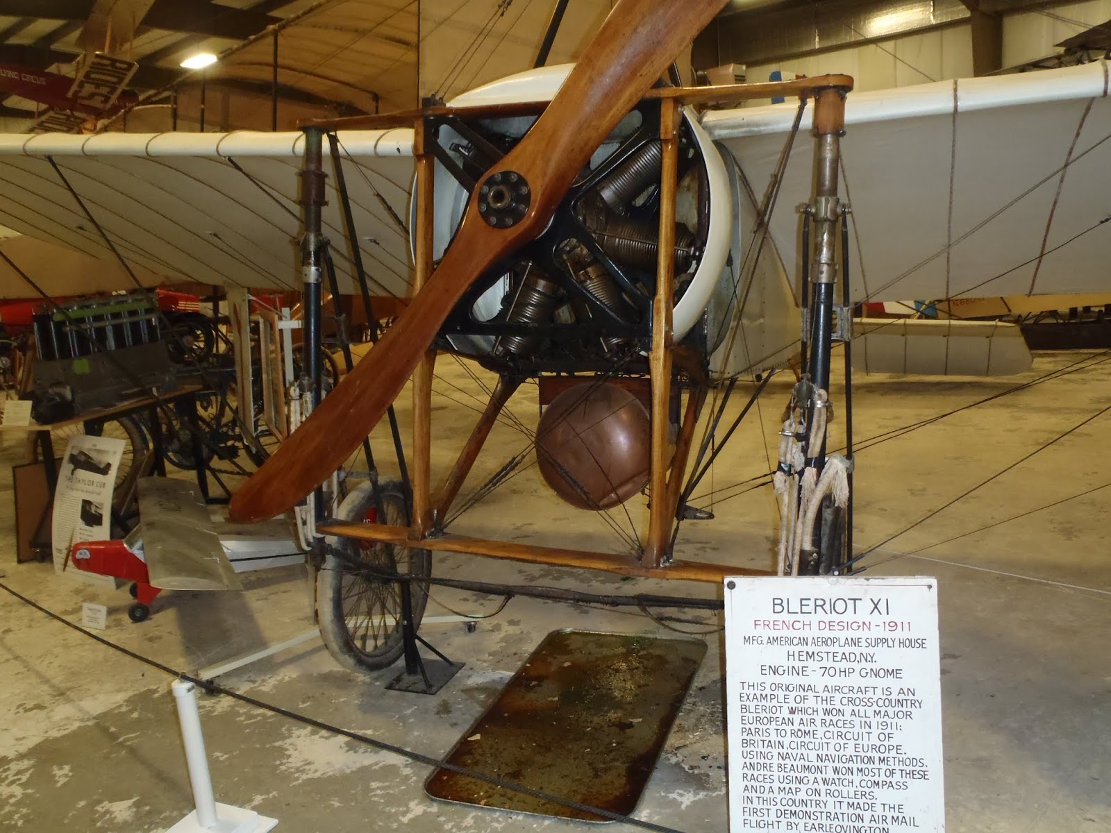
We tour through the gardens and head back to SummerTime. After dinner we go to a grocery store with the rental car and do minor re-provisioning. We stop at a Dairy Queen on the way back to SummerTime for a Blizzard. We both had voted on this option as we had not had a Blizzard since leaving Hampton in June. I text my daughter that "I am slumming" eating at a Dairy Queen. Not true, but after all the other special creameries we have experienced, it seems that way. We get up Thursday, and decide to keep the rental car another day. We are near Rhinebeck, NY where the Rhinebeck Aerodrome which I have wanted to visit since the 80s is located. We drive out to the Aerodrome to see the plane collection.
All of the planes are pre- WWII. In fact, a good number are pre WW-I when aviation was in its infancy. Most are fabric and wood and in very good shape considering construction materials and age.
There is also the fact that they are all stored in period hangers with no environmental control. There are also cars and motorcycles from the same periods exhibited with the planes. There are engines for planes from the period displayed around the buildings, and one can not help but wonder how some of these engines stayed running long enough to get a plane across the country. There is one main building with a gift shop which is kind of modern. There are three quonset hut style hangers with planes of the same vintage decade in each hanger. Across the parking area and county road is an airfield with more hangers and planes. This area is used on weekends for vintage air craft flying and mock dog fights between the WW-I era planes. We take a tour of this field and the planes also. We take a different route back to SummerTime as the route we came over on in the morning was the road the county fair entrance was on. The Duchess County Fair was in progress and there were delays in transiting the area due to fair attendee traffic. We got back on SummerTime late afternoon.
Friday morning I awoke to noise outside our port hull. When I looked out from behind the curtain, I could see a white steel hull with depth marks on it. I got Barbara up and told her I thought a research vessel must have come to the dock. When we later opened the curtains, we could see an 80' USCG patrol boat, the "SHRIKE" on the other side of the pier. I finished getting ready, returned the rental car to Enterprise, and they brought me back to SummerTime. When I get back there are two more USCG boats at the dock, and the USCG Auxiliary has a tent set up at the end of the dock. The USCG and the NY State Department of Environment and Conservation are doing a local water safety program. There are now dignitaries on the dock, and they are boarding the "SHRIKE".
The "SHRIKE" pulls away with its passengers, and we ourselves complete getting ready to leave. There are still Coast Guardsman on the dock, including one press officer with a camera. I make sure to make a good departure from the tight area I am in. There is no wind this morning, and the current is near slack, so it is easy to look good backing away from the dock.
We head down river to find a dock. Not long after we get away, the dockmaster at Tarrytown texts us that he is not able to provide dock space for us this night. I call another marina farther south and get a slip arranged. This changes our plans to stay a day in Tarrytown and tour. Cornetta's Restaurant and Marina in Piermont has space for us.This area is supposed to have a shopping area also, so maybe it is not too bad that we are not going to Tarrytown. We continue down the river. Everything looks different to us. We have been North on the Hudson twice, but never south. When we get to West Point, we are looking at it from a whole different perspective. We see some things we have not seen before. A cut set of stone steps leading to the river in one place. A hill with what looks to be an informal amphi-theatre in front of a small band shell.
It is still an impressive place to look at even from the opposite direction. We pass by Peekskill where we driving in the rain only a month ago. It looks much better in sunlight. As we pass under the Tappan Zee Bridge, we can see that the cranes have removed more of the old bridge structure in the month since we have passed. From here we can see the peninsula that is Piermont jutting out into the Hudson. This is a shallow bay on the charts and we slow down to creep in as there is no marked channel. I show 4-5' of water, and though the bottom of our keel is about 3', the prop still stirs the mud when we are in the 4' areas. There is no marking on the marina walls, so we go to the wrong marina first. We turn around, stirring mud with our prop wash. At Cornettas, just south of the Tappan Zee Marina we pulled up to, it is even shallower. The person on the phone tells me to stay out at the last piers, and just pick "an empty slip" and be able to to tell the number to the barkeeper where I check in. Here in this channel the keel actually seems to be touching. Backing and turning takes a lot of effort. We get tied up, and I go in to register. The dining area off of the bar is very nice, with white table cloths on the tables. After cleaning up, Barbara and I come back to Cornettas Restaurant for dinner.
This has been a good week that we have traveled down the Hudson. We have taken time to see some of the sites on the River, and we did the river in 5 days instead of 2. Along the way we ate at some restaurants with impressive foods. From hot dog restaurant, to diner, to white table cloths, we have sampled some prime eating spots in the Hudson Valley.
The guides only have two marinas for Saugerties. We have not been able to get in touch with one for a slip reservation, but decide to leave anyway. We can always find a cove to anchor in. Part way down the River to Saugerties, one of the marinas finally returns our phone call. We make arrangements for a slip for two nights, though the marina operator warns us that a lot of debris is coming down the Saugerties River from the recent rains.
 |
| LOG WASHED DOWNSTREAM FROM MOUNTAIN RAINS |
 |
| SAUGERTIES LIGHT |
 |
| HISTORIC DESIGNATION |
 |
| VILLAGE ART |
 |
| ONE OF MANY HISTORIC BUILDINGS |
On Tuesday we leave Saugerties headed for Poughkeepsie, New York. We made a reservation on Monday for a Wednesday lunch at "The Culinary Institute of America". The ride down the Hudson to Poughkeepsie is almost as impressive as going down Lake Champlain. The Catskills come almost down to the river's edge at some points. There are a number of interesting little towns along the way, but we pass through them all, albeit at a slower pace than in the past.
 |
| COMMERCIAL TRAFFIC PASSING BY ONE OF MANY RIVER LIGHTHOUSES |
 |
| NORTH AND WEST (RIVER) SIDES OF VANDERBILT HOUSE |
 |
| CULINARY INSTITUTE ENTRY |
 |
| VIEW TO KITCHEN |
We have used our NPS Senior Cards now twice today for admission. A good deal when you are old enough to buy one, as every park is free. We get processed just in time to start on the next guided tour. The Ranger starts with a talk in the main lobby of the Welcome Center, and we move out from there to the Library, a separate tour.
 |
| FDR LIBRARY |
 |
| CATSKILL VALLEY VIEW FROM FDR HOUSE FRONT |
 |
| RHINEBECK AERODROME WELCOME SIGN |
 |
| VERY EARLY PLANE |
Friday morning I awoke to noise outside our port hull. When I looked out from behind the curtain, I could see a white steel hull with depth marks on it. I got Barbara up and told her I thought a research vessel must have come to the dock. When we later opened the curtains, we could see an 80' USCG patrol boat, the "SHRIKE" on the other side of the pier. I finished getting ready, returned the rental car to Enterprise, and they brought me back to SummerTime. When I get back there are two more USCG boats at the dock, and the USCG Auxiliary has a tent set up at the end of the dock. The USCG and the NY State Department of Environment and Conservation are doing a local water safety program. There are now dignitaries on the dock, and they are boarding the "SHRIKE".
 |
| SHRIKE WITH LOCAL DIGNITARIES |
We head down river to find a dock. Not long after we get away, the dockmaster at Tarrytown texts us that he is not able to provide dock space for us this night. I call another marina farther south and get a slip arranged. This changes our plans to stay a day in Tarrytown and tour. Cornetta's Restaurant and Marina in Piermont has space for us.This area is supposed to have a shopping area also, so maybe it is not too bad that we are not going to Tarrytown. We continue down the river. Everything looks different to us. We have been North on the Hudson twice, but never south. When we get to West Point, we are looking at it from a whole different perspective. We see some things we have not seen before. A cut set of stone steps leading to the river in one place. A hill with what looks to be an informal amphi-theatre in front of a small band shell.
 |
| WEST POINT GROUNDS |
This has been a good week that we have traveled down the Hudson. We have taken time to see some of the sites on the River, and we did the river in 5 days instead of 2. Along the way we ate at some restaurants with impressive foods. From hot dog restaurant, to diner, to white table cloths, we have sampled some prime eating spots in the Hudson Valley.
 |
| HYDE PARK DINER WHERE WE HAD LUNCH |
Friday, August 31, 2018
Little Triangle Loop, Week #8, 11-17Aug018, LAKE CHAMPLAIN & CANAL
Burlington is the largest city in Vermont. It is also very beautiful, sitting between the Green Mountains and Lake Champlain, with the taller Adirondacks of New York across the Lake to look at. I eat a bowl of cereal on Saturday morning, and strike out to hopefully get a haircut. I also take checks to the mail drop box to pay bills our daughter had scanned to us. Sometimes we are lucky, and there is a post office near the waterfront. Other times we have the marina take the envelopes from us in their outgoing mail. Today it is a drop box we spotted last evening on the way back from City Market. Back at SummerTime I get Barbara to get her shoes on. Burlington has a Saturday farmers market we are going to go to. We miss the bus, so we walk the .4 miles up the hill to the City square. This is the biggest of the different farmers markets we have been at.
It also has the most attendance of local farmers with local produce of any place we have seen. Besides the local produce, there is fresh baked bread, honey, jellies, milk, cheese, fresh meat, herbs, flower bouquets, and distilled spirits. The last surprises me, as I would have expected that booze could not be sold out in the open city square. That is one of the good parts about this country, every county, city, or village and each state is different. We get an "All Day" sandwich from one of the farm vendors for lunch. It is a whole fried egg, a big sausage patty (this is a pork farmer), onion sauce, cheese spread, on a special baked bun. I get two lemonades from a different vendor to chase the sandwiches with. We sit in front of the wading pool and watch the little children play in it while their moms watch. We buy some produce and head back to SummerTime to get ready to meet our friends here as planned months ago. We are going on the Green Mountain Dinner Train this evening.
Tim and Sue show up at SummerTime about 4:30, and after a few minutes of greetings and salutations, we walk over to the Rail Depot. We are seated at a table in a dining car almost as soon as we get there for our approximate 34 mi. trip to Middlebury, VT. The day is sunny, and though riding backwards, I am still enjoying the views of the lake and mountains out the window. Our orders are taken, and our meal served as advertised while we ride along admiring the scenery.
It does not seem like a long time, and we are at Middlebury on a siding. The engine changes ends on the line of cars, and pulls us back downhill to Burlington. It is a delightful trip with excellent food and great company of old friends. Even though it has been 3 hours since leaving the station, it seems like just a few minutes. We say goodbye until Sunday when we will meet again.
Barbara bakes biscuits again this Sunday, and we have eggs and bacon with them. We are now eating the Strawberry-Rhubarb jam we bought at the Cheese Festival in Little Falls. I am also eating the honey we bought there with butter and biscuits. We get ready and timing is such that we catch the shuttle bus up the hill to go to church. We only have to walk about an half block from the bus stop to the First Baptist Church. After church we walk back to SummerTime. We have only been on board a few minutes when Tim and Sue call on their way to pick us up to go to the Shelburne Museum. This is a museum of 39 buildings on 45 acres. It is a vast collection of "Americana" collected by Electra Havemeyer Webb. One of the first buildings we visited had a collection of sleighs and carriages. I had never seem so many sleighs, mostly horse drawn, in one place.
The carriage collection was nearly as impressive. Another building had a collection of hand made quilts, hats, and even "Samplers" that Mrs. Webb had collected. One of the last buildings we visited on the way out was a collection of Vermont made firearms, mostly long guns. In fact a number of them were specialized target rifles. There was also a collection of stuffed trophy animals in an Adirondack Hunting Lodge relocated to the grounds as an exhibit.
Some of these trophies Mrs. Webb had shot herself, at least one being a Kodiak Brown Bear. Some of the buildings were moved to the museum grounds from other areas as they were significant items in the development of America. Perhaps the biggest item on display, was the 220' steamship "TICONDEROGA" which was moved from the Lake up to its resting place on the museum grounds.
The inside is as it would have been when hauling passengers from its initial launch in 1906. And there was a Merry-go-round that rides could still be had on. It was an impressive place. We did not see it all. Just highlights that each of us thought would be interesting. Afterwards we went back to Burlington, and had dinner at a Pizza Pub on Church Street. And of course we had an ice cream at Ben and Jerry's flagship store on Church Street. Their factory is only about 30 miles from Burlington.
Monday saw Barbara and I prepare SummerTime for the trip down Lake Champlain. Burlington is almost at the halfway point on the long skinny lake. It was another mild weather day as we traveled south. We were surrounded by mountains on both sides of the lake. We also crossed deeper water down through these parts, some places showing well over 300' on SummerTime's chart plotter/depth gauge. About halfway towards the south end of the lake we passed by the "Basin". Floating in its was a replica of Benedict Arnold's gun boat.
We detoured off our straight route, and motored into the "Basin" to get a good photo and look at the gunboat. When we got a little farther south, to the point where the lake really narrows, we pass by Crown Point. There are British and French forts here from colonial times. There is also a large monument to Champlain himself.
From this point on, the Lake is narrow, more like a wide river than a lake. About 48 miles after leaving Burlington, we come to Fort Ticonderoga. The south side is listed to be a good anchorage as long as there are not strong winds from the south. The winds today are light and from an easterly direction.
We anchor under the guns of the Fort's south side.I set up both GPS/chartplotters as anchor alarms. Set up like this, the units will wake you if the boat moves more than a pre-determined distance. There are rain showers forecast for early morning, and a wind shift when the rain comes. It is not too hot, and we cook a simple meal in the microwave so we do not use the generator. We both retire early. The rain comes in the early morning, and the winds shift. The lower helm GPS wakes me with a "beeping" to let me know the boat has moved more than the distance input for the alarm. This distance is based on anchor rode put out and the depth of the water among a few other things. I look at the plot on the screen, and we have moved, but are still in deep water, and no closer to a shore line. We moved closer to the lake channel. I take a spotlight and try to verify our new position to see if we are truly in a safe location. In the rain, I am not able to see shore that well, but lights from the houses in the distance are still close to where they should be. I go back to bed and the rain hitting on the fiberglass roof over my head puts me back to sleep.
We awake, and I make a cup of instant coffee using the microwave. In fact there is enough energy in the batteries after a night on the anchor to heat 3 cups of water. I am a little amazed as the microwave is a big energy user, and running off batteries through the inverter it takes a lot of amps out of the batteries. There were a lot of weeds in the shallow water behind where we anchored last evening. When we go to pull anchor, I am sure the rode is going to be wrapped in them since we did swing during the night. We did not have many weeds, but we did snag someone's lost fishing lure and about 20' of monofilament line. And there is mud on the anchor and chain part of the rode. A good sign as it means the bottom was soft enough to let the anchor set, and hard enough to keep it from pulling out. Barbara gets us moving down the lake as I rinse the mud off the anchor and chain using buckets of water. Once moving, she calls Whitehall Marina and gets us docking space for the evening. About halfway to Whitehall, or 2 hours in, while still riding on the border of NY and Vermont, we see three strange pieces of equipment in the lake ahead of us. As we get closer we see that they are maneuvering in weed beds in the shallows to the side of the lake. As we pass by, we see that what looks like a tractor at a distance, is actually a barge with a sickle type cutter head that can be lowered under the water to cut the weeds. There is a conveyor chain to take the cut weeds to a hopper area at the aft end of the barge. And to make it look more like a tractor, there are paddle wheels stuck out each side providing propulsion.
One of the units down the lake for about a mile, and watch as it turns up into what looks to be a dumping area for the cut weeds. Another thing has occurred on our trip this morning. AMTRAK is again running along the banks beside us as we travel south.
And there is the occasional freight train. We get to Whitehall shortly after lunch. Whitehall touts itself "as the birthplace of the US Navy". There is a small museum here, and after lunch we head up to the museum.
It has a pretty good section on the role the town's sawmills played in the construction of a fleet of boats for the colonists to challenge the British on Lake Champlain. This fleet, including Arnold's gunboat, fought the British fleet by Valcour Island. While the US fleet was defeated, it significantly slowed the advance of the previously unchallenged British fleet. There are models and artifacts documenting this part of our history. The best artifact is in a shed along the canal to the south of the museum. This shed covers the remains of the hull of the "TICONDEROGA" raised from the depths of Lake Champlain in 1959.
This ship helped protect the new nation from the British fleet on Lake Champlain during the War of 1812. The museum is housed in the terminal station for the last and northern most lock on the Champlain canal. The State of NY gave the building to the town for its bicentennial celebration as long as it ran a museum. The towns people brought all kinds of things out of their basements for museum displays. There were old typewriters, sewing machines (non Singer), furniture, kitchen appliances, and mostly you name it. As we left the museum, we walked along the lock wall where we met the owners of "Ping", a former looper boat from Oxford, MD. There are thunderstorms in the area again, and after a few minutes of chatting, we head back to SummerTime. We freshen up and go up the ramp from the docks to the main Marina Building. The restaurant located in there is supposed to have very good food. We are not disappointed, as the red sauce on my spaghetti is as good as any I have ever tasted. Barbara's shrimp in an Alfredo sauce was also great according to her. It rained hard while we were eating, and quit long enough for us to get to SummerTime without getting wet.
On Wednesday morning we dress and head back into the small town area to eat breakfast at "Historic Grounds". We meet and sit with Margy and Jim from Ping there. We talk about cruising and the amazing breakfast we are having. I have two blueberry pancakes the size of a dinner plate. They are excellent. Barbara ordered one scrambled egg, and it is the size of a 3 egg omelet at most other places. The owner asks us about our meals and we tell him that they are excellent. We have eaten at two restaurants in this small town and were blown away by the quantity, quality, and taste of the food. We head back to SummerTime and ready to leave. We have to lower her mast (3 pins and it lifts off its base and lays to the side) as there are some bridges along this route that are 17', a little shorter than our mast height of 18'. The Canadian couple on the boat beside us help us get away. They are headed all the way to New York City form LaChene, suburb of Montreal we learn. They are awaiting a part to repair their boat. We back out, and I call the operator at Lock #12 for an opening and lift. In 10 minutes, we are on our way up 35'. We head out at only 8mph as this is a dug or constructed canal and has a speed limit of 10mph. Most of the ride is through farm country or forests.
There is almost no industry that we can see along here. We do pass what appears to be one loading area for a quarry with a barge at it. As we approach Lock #8, we are hailed by a tug leaving it. The "Edna A" is pushing a barge north, and asks us to hold in a cove so she can pass in the middle. There is no cove, just a slight widening that I ease over in.
I maneuver as close to the edge as I dare, to about a 5' depth 20' from the shore, and we pass by the "Edna A" with plenty of room to spare. We enter Lock #8, and we are now being lowered to a new elevation. We proceed on to Lock #7, and at Fort Edward, we are lowered to the level of the Hudson River coming out of the Adirondacks to the west. At the end of the lock walls, we make a 180 degree turn back along side the lock and travel about 2 miles to the town dock. There is a protected area to tie-up with free power available. As Barbara prepares dinner, I walk to the nearby convenience store and buy milk, bread, and a couple other grocery items for the boat. After dinner, we walk the other direction to a "Stewarts Shop" where we get an ice cream cone each. I am beginning to like this little chain of "Stewart Shops" convenience stores in Central New York. We walk back to SummerTime in the dark, except for the park we are tied up in, which is lit pretty good.
We have a lot of locks to do today, so we try to get going early. We get away from the Fort Edward town dock at 8:16. About an half mile from the town dock, an eagle flies from the edge of the river out in front of us.
It is only about 300yd from the nearest back yard. I am not sure it is the closest we have been to one, but it is the closest we have seen one to residences. It is a nice, surprising sight first thing in the morning. I barely have time to grab one of the two cameras we keep on the fly bridge when traveling. And there is the camera on my phone also. We continue on, and in a few minutes we are going back south along the outside of lock #7. Now that this is a river route, and not just a man made canal, NY raises the speed limit. We go back to cruising at 1800rpm, which is about 8.9mph in still wind and current conditions. We get to lock #6 fairly quickly, the lock is open and waiting on us so we go straight in. Locks 5 & 4 are pretty much the same. The scenery along the river is farmland and private residences. We do pass one island in the river that has an airfield on it. The other side of the island is a section of the river used for seaplanes. The wind is up when we get to Lock #3. It is in a direction that is moving us around in the lock. Barbara's 11,000 pounds of boat on the end of a short rope is working both of us as I sometimes have to loose my end so she can pull her end of the boat in. It is a good thing there are no other boats in this lock with us. Somewhere between locks #2 & #3 the Perkins passes the 3000hr mark. It had about 1665 hours showing when we bought Summertime in April of 2013. We also pass by Saratoga Battlefield, now a National Park.
The cleared hills, some narrow roads, and two cannons perched up on a hill are the clues to us this a Historic Park. At lock #1, we are requested to hold short of the lock. There is a tug with barge in the lock they are raising up to go north. After the tug comes out, we motor into the lock. We are followed by about a 40ft houseboat headed south like us.
They followed us down river to Troy Lock, or The Federal Lock, as it is known by some. It is the only lock on the Hudson and Erie Systems that is not operated by the State of NY. We have to wait here to get locked down also. While waiting I call Shady Harbor Marina in New Baltimore, about 25 miles south of Troy Lock, to reserve a slip. We know we can not stay at Waterford as there is a big dragon boat race being staged from the Waterford docks this weekend. Shady Harbor confirms they can have a slip for us, and Troy Lock opens the gates for us to enter. When we exit Troy Lock, I let the house boat named: "Watta Life" by. They have concerns about speed enforcements in a construction zone by the Troy town docks. They are re-building the town docks, and I do see one barge worker motioning a north bound boat to slow down. "Watta Life" pulls over to the Yacht Club in Albany to fuel. A lot of boats stop at the Albany Yacht Club as they have the cheapest fuel in the area. We pass by them and speed up on our way south. We got to Shady Harbor about 5pm. They assigned us a slip on one of their piers we had not been at before. The Canadians from White Hall show up in their express cruiser about 5:30, and they are put in the slip next to us. They got their new electrical parts installed late Wednesday, and have come from White Hall in one day. I am amazed as it means that they have done 12 locks in one day, while traveling about 88 miles. Barbara and I shower aboard, and go up to the restaurant: Boathouse Grille to eat. They have a very good and varied menu. And their chefs are excellent in their craft.
On Friday we borrow the courtesy car from the marina and go do grocery shopping. It is the first full grocery store we have been in since Vallleyfield, Quebec. And it is the first time we have had a car where we could really load up to haul stuff since Winter Harbor in Brewerton, NY on 18 July. When we passed Waterford on Thursday, we closed the sides on our triangle. We are now back on a return trip to our starting point in Virginia. We hurried up the Hudson both of our previous trips. We have no schedule as of this date, so we are going to take time and see some of the sights on the Hudson on our way back down it.
 |
| SATURDAY FARMERS MARKET IN BURLINGTON, VT |
Tim and Sue show up at SummerTime about 4:30, and after a few minutes of greetings and salutations, we walk over to the Rail Depot. We are seated at a table in a dining car almost as soon as we get there for our approximate 34 mi. trip to Middlebury, VT. The day is sunny, and though riding backwards, I am still enjoying the views of the lake and mountains out the window. Our orders are taken, and our meal served as advertised while we ride along admiring the scenery.
 |
| VIEW FROM TRAIN WINDOW |
Barbara bakes biscuits again this Sunday, and we have eggs and bacon with them. We are now eating the Strawberry-Rhubarb jam we bought at the Cheese Festival in Little Falls. I am also eating the honey we bought there with butter and biscuits. We get ready and timing is such that we catch the shuttle bus up the hill to go to church. We only have to walk about an half block from the bus stop to the First Baptist Church. After church we walk back to SummerTime. We have only been on board a few minutes when Tim and Sue call on their way to pick us up to go to the Shelburne Museum. This is a museum of 39 buildings on 45 acres. It is a vast collection of "Americana" collected by Electra Havemeyer Webb. One of the first buildings we visited had a collection of sleighs and carriages. I had never seem so many sleighs, mostly horse drawn, in one place.
 |
| SLEIGH & CARRIAGE COLLECTION AT SHELBURNE MUSEUM |
 |
| TROPHY COLLECTION |
 |
| "TICONDEROGA" FINAL DOCK |
 |
| TICONDEROGA DINING AREA |
 |
| BURLINGTON MARINA PAY SHOWERS, A FIRST |
 |
| BENEDICT ARNOLD'S GUN BOAT |
 |
| CROWN POINT MEMORIAL |
 |
| FORT TICONDEROGA'S SOUTH SIDE |
We awake, and I make a cup of instant coffee using the microwave. In fact there is enough energy in the batteries after a night on the anchor to heat 3 cups of water. I am a little amazed as the microwave is a big energy user, and running off batteries through the inverter it takes a lot of amps out of the batteries. There were a lot of weeds in the shallow water behind where we anchored last evening. When we go to pull anchor, I am sure the rode is going to be wrapped in them since we did swing during the night. We did not have many weeds, but we did snag someone's lost fishing lure and about 20' of monofilament line. And there is mud on the anchor and chain part of the rode. A good sign as it means the bottom was soft enough to let the anchor set, and hard enough to keep it from pulling out. Barbara gets us moving down the lake as I rinse the mud off the anchor and chain using buckets of water. Once moving, she calls Whitehall Marina and gets us docking space for the evening. About halfway to Whitehall, or 2 hours in, while still riding on the border of NY and Vermont, we see three strange pieces of equipment in the lake ahead of us. As we get closer we see that they are maneuvering in weed beds in the shallows to the side of the lake. As we pass by, we see that what looks like a tractor at a distance, is actually a barge with a sickle type cutter head that can be lowered under the water to cut the weeds. There is a conveyor chain to take the cut weeds to a hopper area at the aft end of the barge. And to make it look more like a tractor, there are paddle wheels stuck out each side providing propulsion.
 |
| VERMONT WEED HARVESTERS |
 |
| AMTRAK PASSING PAPER MILL |
 |
| WHITEHALL MUSEUM PLAQUE |
 |
| REMAINS OF TICONDEROGA HULL |
On Wednesday morning we dress and head back into the small town area to eat breakfast at "Historic Grounds". We meet and sit with Margy and Jim from Ping there. We talk about cruising and the amazing breakfast we are having. I have two blueberry pancakes the size of a dinner plate. They are excellent. Barbara ordered one scrambled egg, and it is the size of a 3 egg omelet at most other places. The owner asks us about our meals and we tell him that they are excellent. We have eaten at two restaurants in this small town and were blown away by the quantity, quality, and taste of the food. We head back to SummerTime and ready to leave. We have to lower her mast (3 pins and it lifts off its base and lays to the side) as there are some bridges along this route that are 17', a little shorter than our mast height of 18'. The Canadian couple on the boat beside us help us get away. They are headed all the way to New York City form LaChene, suburb of Montreal we learn. They are awaiting a part to repair their boat. We back out, and I call the operator at Lock #12 for an opening and lift. In 10 minutes, we are on our way up 35'. We head out at only 8mph as this is a dug or constructed canal and has a speed limit of 10mph. Most of the ride is through farm country or forests.
 |
| WILDLIFE ALONG THE CHAMPLAIN CANAL |
 |
| MEETING A TOW (TUG & BARGE) ON AN ANCIENT CANAL |
We have a lot of locks to do today, so we try to get going early. We get away from the Fort Edward town dock at 8:16. About an half mile from the town dock, an eagle flies from the edge of the river out in front of us.
 |
| URBAN EAGLE |
 |
| SARATOGA NATIONAL PARK WITH CANNON ON HILL |
 |
| BACK AT WATERFORD, NY WHERE CANALS SPLIT |
On Friday we borrow the courtesy car from the marina and go do grocery shopping. It is the first full grocery store we have been in since Vallleyfield, Quebec. And it is the first time we have had a car where we could really load up to haul stuff since Winter Harbor in Brewerton, NY on 18 July. When we passed Waterford on Thursday, we closed the sides on our triangle. We are now back on a return trip to our starting point in Virginia. We hurried up the Hudson both of our previous trips. We have no schedule as of this date, so we are going to take time and see some of the sights on the Hudson on our way back down it.
Thursday, August 23, 2018
Little Triangle Loop, Week #7, 4-10August018 - NEW CULTURE
Saturday we are up making plans to go museum hopping in Old Montreal. There are a number of museums available within walking distance of the docks. We are trying to pick ones near the Old Town Harbor that we can easily walk to, and that appeal to us. Even as we leave to go to the first museum at opening, the docks are already milling with families taking advantage of the entertainment venues.
There is a huge ferris wheel, but what gets my attention is a an adult/larger children venue of ropes, swings, and ladders. It looks like a simpler version of the "American Ninja Warrior" TV series.
We eventually get to the Marguerite-Bourgeoys Museum and Notre-Dame-de-Bon-Secours Chapel. This "Sailors Church" was founded in 1655 by Marguerite Bourgeoys. We got there in time for the guide tour under the current church's foundations where an archaeological dig was done in the 2000s. There is also an adjacent crypt, which is nothing like I envisioned from the Indiana Jones movies. One of the main parts of this museum is a room full of miniature dioramas portraying the different parts of Marguerite's life from a little girl until on her death bed. Very detailed displays done in miniature. I also go up to the walkway between the steeples and get a great view of the harbor.
From this museum and Chapel tour we go to lunch up on Place Jacques-Cartier at a sidewalk cafe. The Place Jacques-Cartier ( a boulevard) is a pedestrian walkway filled with people, entertainers, and shops and restaurants down each side.
After lunch we go to the Chateau-Ramezay Historic Site and Museum of Montreal. This was originally built in very early 1700s as a Governor of Montreal's house when the French were in control of Canada. It was build quite opulent, with the builder boasting it was better than the territorial governor's residence. It is now a museum which tells the history of Montreal. It has a lovely colonial garden of flowers and vegetables in back.
Between the two museums our legs are worn out. We go back to SummerTime and rest up before going out to dinner. We go to a French restaurant on Rue Saint-Paul Est where I get a steak and Barbara gets her lamb. She is fond of lamb, but seldom has it in US as good lamb in grocery stores and restaurants is hard to find. I ask for a Molsens to drink, and find that the restaurant does not carry Molsens. It seems remarkable as we passed their primary brewery on our way up the river, not much more than a mile from where we sit. it was a nice evening and day.
We did not go to a church this Sunday. There is not a Protestant church near within walking distance. The main Notre Dame Basilica is farther than we can walk also. On Google Maps, where I normally find the closest church to the boat, it appears there are no churches with Sunday services closer than a mile to SummerTime. We have our normal Sunday breakfast of biscuits, eggs, and bacon late. We decide we will walk out later to get an ice cream for lunch and walk on Rue Saint-Paul where we were not at on Saturday. It is also closed to vehicular traffic during day and evening hours in the shops and restaurants district. We get our ice cream at one of several creameries along Rue de La Commune Est. We walk to the south end of the tourist area, and go up one block to walk north on Rue Saint-Paul. This end of Saint-Paul is art, fashion, and souvenir shops.
We go in several Art shops and buy a few souvenirs in one of the souvenir shops. Barbara sees a piece of metal sculpture that is a "Fish" in an art shop, and would like to buy it, but reasons herself out of it as there is not room on the boat to carry it back. When we get back to Jacques-Cartier, it is nearly time for dinner. We go to the sidewalk cafe there and order salads and a pizza. Still no Molsen, so I get an Italian brew. The medium pizza turns out to be a mistake for two. After the salads it is too large for us to eat, and we have to ask for a box to take it out with. Crepes are a specialty in this part of town, and we have no room left for the dessert crepes. We go back to SummerTime and retire as it is nearly dark when we get back.
Monday finds us moving to the main dock by the office before leaving. We need a pump out, and they are thorough on how they perform one. It is also the most expensive ever, at $25 before the exchange rate. We are under way headed downstream quickly (still traveling north) on the St. Lawrence River to Sorel.
We pass numerous ships of various kinds loading and unloading as we pass out of Montreal. At one spot, two are side by side in the wide river, transferring a load between them. We see a tug pulling up to one ship and another tug en route to obviously un-berth this ship. It is a fairly easy trip down river. There is a lot of industry along the river, and a number of small towns also near the industry. We also see people recreating on the river, some swimming off their boats. It is hot and I think that they might be smart in what they are doing. We get to Sorel late afternoon and see that there is a number of ships in the anchorage there.
Sorel is an industrial town, and has several industries where it sits at the intersection of the Richelieu River with the St Lawrence Seaway. The ships are waiting in the anchorage for their chance to take on or discharge freight. As we head into the Province run marina, we are nearly run over by a wildlife sightseeing boat. Another person with the title of captain who is not so professional. He is obviously rushing to get his paying customers to dock, but he is not thinking totally about their safety by passing me in such a confined spot. We take our slip that is assigned to us. We are in the marina harbor mouth again, on the outside of the dock. I check in at the harbor office. The English here is not as good as at most of Montreal or Valleyfield. I talk to a couple of local persons, one who recognizes our AGLCA looper burgee on the bow, and quizzes me on our trip before I go back to SummerTime. As I am boarding SummerTime, the ship being un-berthed back in Montreal passes by. The ships move pretty fast when they are not in vicinity of locks on rivers. We stay aboard tonight. There are no attractions close by in this little industrial town that we want to venture out to. They have a small bio or Eco-sphere we can see near the ferry dock, but we are not interested this evening.
It is overcast when we get up on Tuesday morning, and starts to drizzle as I return from taking the trash up to a shore receptacle. We do this nearly every day so there is nothing aboard to attract insects or other vermin. There is a neighbor on the dock with small children, and after talking to him about the Great Loop, he helps us get off.
After we pass the industrial part of Sorel, we come to the waterfront homes along the Richelieu River. They are like the waterfront homes on any other river front. Some are weekend fish camps with a dock, and others are very nice luxury homes with landscaped yards, a dock, and a nice boat at the dock. We are about 2 hours to get to the St. Ours Lock. It is part of Canada's heritage lock systems. The park like setting around it is very nice. Inside the lock there is a floating dock to tie to.
This is a first for us to have a dock in a lock. It is a "fee to use" lock, and the Parks Canada person takes our credit card with a portable card reader as the lock level is being raised. I get a printed receipt from the same portable reader. This has been the norm in Canada. Waiters come to your table with these portable credit card readers, your authorization and approval occurs on the spot, and you get a printed receipt of the transaction. Your credit card never leaves your sight. We continue on the Richelieu River after leaving the lock. I call ahead to make a dock reservation now that I know we will not be delayed by locks or other man made items. Quebec is supposed to be bi-lingual, and most persons there are, but sometimes the English is not so good. The lady who answers the phone tells me to hold when I ask about dockage for the evening, and passes me on to her manager. I apparently started to speak too fast, though being from the south I never think that I speak fast, and the man tells me "his English is not too good, slow down, or he will start speaking French". I slow down my speech and get the reservation made. The rest of our journey today will be on the Richelieu, which we are now traveling south on is more of a recreational river. There are a few small towns along the river, but mostly it is lined with houses. There is little industry. There are a few marinas, or bait stores along the shore, and that is pretty much it for commercial and industrial sightings. The church steeples in these little towns are architectural masterpieces. Each one looks like it was constructed to be more elaborate than the next closest one.
This seemed to start as we came down the St. Lawrence after Montreal. I am thinking that in the late 1800s or early 1900s when this area was developed, that there was a small carpentry company selling elaborate steeples to churches. Later in the afternoon, as we near the Chambly Basin (a shallow lake) we pass a base for seaplanes. There is a ramp down to the rivers edge, and a number of planes on wheeled (amphibious) floats are parked up on the grass. They are various size planes, even a DeHaviland Beaver in one spot.
We cross the Chambly Basin and go straight to Chambly Marina. We take a slip for the evening. We head to a French restaurant for dinner, but despite what "Google Maps" says about being open, the place is closed for the day. We backtrack to the other side of the town to a Portuguese restaurant. We have a good meal, most of their entrees are seafood (several mussel and octopus dishes) and pass on dessert there. We passed two ice cream parlors on the way to the restaurant. We stop at one on the way back to SummerTime and get a cone each. It is good ice cream, but not in the top five. We retire early back on SummerTime, Wednesday will be a long day and start early.
As we are preparing to get underway on Wednesday morning, another boat pulls into the marina and takes on gas. They get out a few minutes in front of us and around the sea wall to wait in line for the locks to open. We are behind them by a few minutes, rounding the sea wall to the lock waiting point at 9a.m., when the locks are supposed to open. The lock master comes down the dock and tells the waiting boats what order to go in, and collects the prepaid tickets. We are told there is not room for us on this lock up, but they will get us on the next one. Five boats enter the lock, 2 wide, and we and a large pontoon boat wait our turn for the lock. There are three locks together here. When the first 5 boats leave the first lock, two boats waiting in the Chambly canal on the other side come down. We are now directed to enter the lock along with the pontoon boat. These are antique, or "Heritage" locks. They have wooden gates, that are operated by manual cranks. The valves to let water in and out of the locks are simple slide gates on the lock doors that also are operated with a hand crank.
Most all the persons operating these locks appear to be college students on their summer jobs with Parks Canada. We will traverse 9 locks today in about 10 miles. The first three locks are together, or flight locks, where you go directly from one to the next on your way up or down in elevation. There are 5 persons taking turns on these gates, 8 for the three locks. And there is a swing bridge on the canal side of lock #3, the only thing with electrical power other than the signal locks. Just before 11 we are out of the first three locks. It is not too far, and we encounter locks 4, 5 & 6. They are farther apart, and have a crew of 2-3 for each lock. Lock 4 is the smallest of the ones we will go through today. There is not room for the10' beam of the pontoon boat, and SummerTime's 12' beam to be side by side with fenders. We are end to end on opposite sides of the lock. Both boats nearly fill this small lock. We also have a couple of low bridges on the Chambly canal. The operators speed from one bridge to the next to have them open in time for us. The bridges are narrow. At the first bridge, boats wait to the side on the opposite side of the bridge until we pass, then they go through the bridge.
At bridge 10, we have to wait for the boats coming north. We also waited at one lock for the north bound boats, and as they got nearly to the lock, we pulled out to the starboard (right) side in a basin area, and let the incoming boats pass into the lock. When the last of the boats was by, we proceeded on our way south with the pontoon boat behind us. This is all very tedious, requiring good timing on some lock people's part, and taking the better part of a day. We clear the last of the Chambly locks and bridges about 3:30. We have made arrangements with a marina at Rouses Point in NY on Lake Champlain for a slip for tonight.
Before we can get to our marina, just over the US/Canada border we have to clear US Customs and Border Patrol (CBP). We had tried to use the new "ROAM" app for customs while in the canal waiting on one of the bridges. It would not work without a "wifi" connection, so we called the 800 number to check in for boaters. The agent on the other end was very pleasant, but told us we could not check in via phone more than an hour before arrival. He suggested Rouses Point CBP when we crossed the border. As we traveled into Lake Champlain from the Chambly Canal/ Richelieu River, I pondered what to do about checking in. It was clear the convenience of the "ROAM" app was not going to work. Checking in by phone takes a good signal, that did not work at Bainsville, Ontario. I decide to pull to the docks of CBP. They have a small office trailer on the point under the Highway 2 bridge which is easy to see when we cross the border a mile and a half from their position. They have alternating flashing red and blue lights. It is obvious, even from a distance, that there is some kind of law enforcement ahead. We tie-up and I go to get interviewed. They can see Barbara on the boat deck securing lines, and tell me she needs to come up also. They take our passports, and provide a stamped document to say we have re-entered the US. The whole thing took less time than our doing the "ROAM" app leaving Morrisburg, Ontario, or the call ins we have previously done coming back into the US. The office and docks on the little peninsula is what made it easy.
I had called Barcomb's Marina about 1/2 hour before getting to customs, explaining we could not be there by 5-5:30 per my original plans. The dockmaster gave me instructions for tie-ing up when we arrived. A little after 6 we left CBP, and were at the dock by 6:15. The border, CBP, and the marina were all that close. We tied up, Barbara fixed a simple meal for the evening, and we took a well deserved rest. We had not done that many miles today, but we did 9 locks and 3 bridges. A big day for the two of us.
We decide to stay and extra night when I check in on Thursday morning. We need to do laundry and buy some groceries to put aboard. Barcomb's has a courtesy car and I borrow the keys as there is not a laundry at the marina. The marina people give us directions to the laundromat in town. They also give us directions to a grocery store, and tell us of a deli near the laundromat. We leave the laundromat, and stop at the Dollar General we had passed. Barbara buys the staples she can from them, but no milk, and we go back to the marina to return the car. We have now had the two extremes in marina courtesy cars. The 1993 Oldsmobile in Smithville coming down the Tenn-Tom, and now this one. It was a nearly new KIA Sedona van with only 3400 miles. We eat at the bar/grill above the marina store/office. It is windy out, and we are glad we took a day to do chores. We are not to be in Burlington until Friday, and this marina is .75/ft less per night than Burlington.
Friday we get up and make ready to leave. We go over to the "Service Docks" (4 finger piers) and take on fuel. This is the first time we have fueled since Crysler Marine Park in Morrisburg, ON. It takes 83.4 gallons for 36 hour of running time covering 241mi, and 1-1/2hr of generator time. Traveling downriver on the St Lawrence was a big help, and we only had 2 times for about 3 hours where we ran at 85-90% power. We went upriver on the Richelieu, but its current is nothing compared to the 2-3mph of the St. Lawrence. This was better than I had hoped for when we topped off the tank at Crysler Marine Park. We have been 1185 miles since leaving Hampton, VA on 23 June. We have burned 562 gallons of fuel in those miles.
We head south on Lake Champlain to Burlington, VT. The lake has some shallow spots in this north end, and we follow the zig-zag route of the buoys. Lake Champlain is relatively calm as the winds are light. We meet a lot of power boats going north. I am assuming it is Canadians headed home after vacation. They will spend the same 5-1/2hr on the Chambly Canal that we did. Besides the locks and bridges, there is a 6mph speed limit on the canal proper. We also are seeing a number of sail boats on Lake Champlain as we get farther south where the lake is wider. They are trying to sail, but the wind is a little light for good sailing. But the wind is just about right for a good power boat cruise. There is not a lot of development on this upper part of Lake Champlain. And the views are gorgeous with mountains on both sides. We get to Burlington about 4:30 after about 41 miles.
There is a lot of traffic as we approach the harbor. There are tour boats, ferries, and then the fishing and cruising boats. After securing everything and checking in, Barbara and I take the free shuttle bus into town to find the grocery store. We get the milk we have been out of and walk back to SummerTime for the evening.
It is good to get here on the day we had scheduled to arrive. We hurried some times to beat weather, or make up lost time for whatever reason. And there were times when we stopped to smell the roses. It has been a very good trip so far.
 |
| FAMILIES ON THE WHARF @ MORNING |
 |
| FERRIS WHEEL |
There is a huge ferris wheel, but what gets my attention is a an adult/larger children venue of ropes, swings, and ladders. It looks like a simpler version of the "American Ninja Warrior" TV series.
 |
| ADULT ROPE CHALLENGES |
 |
| CRUISE SHIP BEYOND OLD PORT |
 |
| BOATS IN OLD PORT |
From this museum and Chapel tour we go to lunch up on Place Jacques-Cartier at a sidewalk cafe. The Place Jacques-Cartier ( a boulevard) is a pedestrian walkway filled with people, entertainers, and shops and restaurants down each side.
 |
| PLACE JACQUES-CARTIER |
 |
| RAMEZAY GARDEN |
We did not go to a church this Sunday. There is not a Protestant church near within walking distance. The main Notre Dame Basilica is farther than we can walk also. On Google Maps, where I normally find the closest church to the boat, it appears there are no churches with Sunday services closer than a mile to SummerTime. We have our normal Sunday breakfast of biscuits, eggs, and bacon late. We decide we will walk out later to get an ice cream for lunch and walk on Rue Saint-Paul where we were not at on Saturday. It is also closed to vehicular traffic during day and evening hours in the shops and restaurants district. We get our ice cream at one of several creameries along Rue de La Commune Est. We walk to the south end of the tourist area, and go up one block to walk north on Rue Saint-Paul. This end of Saint-Paul is art, fashion, and souvenir shops.
 |
| RUE SAINT-PAUL EST SHOPS |
Monday finds us moving to the main dock by the office before leaving. We need a pump out, and they are thorough on how they perform one. It is also the most expensive ever, at $25 before the exchange rate. We are under way headed downstream quickly (still traveling north) on the St. Lawrence River to Sorel.
 |
| ST LAWRENCE RIVER CURRENT |
 |
| SHIPS IN DESIGNATED ANCHORAGE ON THE SEAWAY |
It is overcast when we get up on Tuesday morning, and starts to drizzle as I return from taking the trash up to a shore receptacle. We do this nearly every day so there is nothing aboard to attract insects or other vermin. There is a neighbor on the dock with small children, and after talking to him about the Great Loop, he helps us get off.
 |
| SHIP LOADING GRAIN ON RICHELIEU RIVER IN SOREL |
 |
| INSIDE THE SAINT OURS LOCK |
 |
| EAST SIDE STEEPLE, ST. HILAIRE |
 |
| WEST SIDE STEEPLE, POINT BELOEIL |
This seemed to start as we came down the St. Lawrence after Montreal. I am thinking that in the late 1800s or early 1900s when this area was developed, that there was a small carpentry company selling elaborate steeples to churches. Later in the afternoon, as we near the Chambly Basin (a shallow lake) we pass a base for seaplanes. There is a ramp down to the rivers edge, and a number of planes on wheeled (amphibious) floats are parked up on the grass. They are various size planes, even a DeHaviland Beaver in one spot.
 |
| SEA PLANES WAITING FOR FLYING |
As we are preparing to get underway on Wednesday morning, another boat pulls into the marina and takes on gas. They get out a few minutes in front of us and around the sea wall to wait in line for the locks to open. We are behind them by a few minutes, rounding the sea wall to the lock waiting point at 9a.m., when the locks are supposed to open. The lock master comes down the dock and tells the waiting boats what order to go in, and collects the prepaid tickets. We are told there is not room for us on this lock up, but they will get us on the next one. Five boats enter the lock, 2 wide, and we and a large pontoon boat wait our turn for the lock. There are three locks together here. When the first 5 boats leave the first lock, two boats waiting in the Chambly canal on the other side come down. We are now directed to enter the lock along with the pontoon boat. These are antique, or "Heritage" locks. They have wooden gates, that are operated by manual cranks. The valves to let water in and out of the locks are simple slide gates on the lock doors that also are operated with a hand crank.
 |
| WOODEN "HERITAGE" LOCK GATES |
 |
| ROOM FOR 1 AT BRIDGE |
Before we can get to our marina, just over the US/Canada border we have to clear US Customs and Border Patrol (CBP). We had tried to use the new "ROAM" app for customs while in the canal waiting on one of the bridges. It would not work without a "wifi" connection, so we called the 800 number to check in for boaters. The agent on the other end was very pleasant, but told us we could not check in via phone more than an hour before arrival. He suggested Rouses Point CBP when we crossed the border. As we traveled into Lake Champlain from the Chambly Canal/ Richelieu River, I pondered what to do about checking in. It was clear the convenience of the "ROAM" app was not going to work. Checking in by phone takes a good signal, that did not work at Bainsville, Ontario. I decide to pull to the docks of CBP. They have a small office trailer on the point under the Highway 2 bridge which is easy to see when we cross the border a mile and a half from their position. They have alternating flashing red and blue lights. It is obvious, even from a distance, that there is some kind of law enforcement ahead. We tie-up and I go to get interviewed. They can see Barbara on the boat deck securing lines, and tell me she needs to come up also. They take our passports, and provide a stamped document to say we have re-entered the US. The whole thing took less time than our doing the "ROAM" app leaving Morrisburg, Ontario, or the call ins we have previously done coming back into the US. The office and docks on the little peninsula is what made it easy.
I had called Barcomb's Marina about 1/2 hour before getting to customs, explaining we could not be there by 5-5:30 per my original plans. The dockmaster gave me instructions for tie-ing up when we arrived. A little after 6 we left CBP, and were at the dock by 6:15. The border, CBP, and the marina were all that close. We tied up, Barbara fixed a simple meal for the evening, and we took a well deserved rest. We had not done that many miles today, but we did 9 locks and 3 bridges. A big day for the two of us.
We decide to stay and extra night when I check in on Thursday morning. We need to do laundry and buy some groceries to put aboard. Barcomb's has a courtesy car and I borrow the keys as there is not a laundry at the marina. The marina people give us directions to the laundromat in town. They also give us directions to a grocery store, and tell us of a deli near the laundromat. We leave the laundromat, and stop at the Dollar General we had passed. Barbara buys the staples she can from them, but no milk, and we go back to the marina to return the car. We have now had the two extremes in marina courtesy cars. The 1993 Oldsmobile in Smithville coming down the Tenn-Tom, and now this one. It was a nearly new KIA Sedona van with only 3400 miles. We eat at the bar/grill above the marina store/office. It is windy out, and we are glad we took a day to do chores. We are not to be in Burlington until Friday, and this marina is .75/ft less per night than Burlington.
Friday we get up and make ready to leave. We go over to the "Service Docks" (4 finger piers) and take on fuel. This is the first time we have fueled since Crysler Marine Park in Morrisburg, ON. It takes 83.4 gallons for 36 hour of running time covering 241mi, and 1-1/2hr of generator time. Traveling downriver on the St Lawrence was a big help, and we only had 2 times for about 3 hours where we ran at 85-90% power. We went upriver on the Richelieu, but its current is nothing compared to the 2-3mph of the St. Lawrence. This was better than I had hoped for when we topped off the tank at Crysler Marine Park. We have been 1185 miles since leaving Hampton, VA on 23 June. We have burned 562 gallons of fuel in those miles.
We head south on Lake Champlain to Burlington, VT. The lake has some shallow spots in this north end, and we follow the zig-zag route of the buoys. Lake Champlain is relatively calm as the winds are light. We meet a lot of power boats going north. I am assuming it is Canadians headed home after vacation. They will spend the same 5-1/2hr on the Chambly Canal that we did. Besides the locks and bridges, there is a 6mph speed limit on the canal proper. We also are seeing a number of sail boats on Lake Champlain as we get farther south where the lake is wider. They are trying to sail, but the wind is a little light for good sailing. But the wind is just about right for a good power boat cruise. There is not a lot of development on this upper part of Lake Champlain. And the views are gorgeous with mountains on both sides. We get to Burlington about 4:30 after about 41 miles.
 |
| APPROACH TO BURLINGTON HARBOR |
There is a lot of traffic as we approach the harbor. There are tour boats, ferries, and then the fishing and cruising boats. After securing everything and checking in, Barbara and I take the free shuttle bus into town to find the grocery store. We get the milk we have been out of and walk back to SummerTime for the evening.
It is good to get here on the day we had scheduled to arrive. We hurried some times to beat weather, or make up lost time for whatever reason. And there were times when we stopped to smell the roses. It has been a very good trip so far.
 |
| SUNSET OVER NY MOUNTAINS SEEN FROM BURLINGTON HARBOR |
Subscribe to:
Posts (Atom)