On Saturday morning, two loopers show up by bicycle at the docks. They are Myron and Linda from Miss Bailey. We had traveled with them from Orange Beach to Pensacola. They are at Turtle Cove Marina at the other end of the GreekTown area. And Herb Seaton, the TS harbor host for the AGLCA comes by while they are there. We decide to move to Turtle Cove from the city docks after Herb drives us there for a tour. Barbara and I check out with the city, and we motor across the river to fuel up before moving on. We put in 55.5gal for the hours (25.5hr) we have put on since Steinhatchee where we last filled. We also had about 2hr (1.8gal) of generator time in that usage. We get a pump out, and it cost as much as some in Mi. Our fuel savings is wiped out by the pump out. Turtle Cove is a relatively new, modern marina with floating docks. And they have all the amenities. Barbara uses the laundry room to clean clothes, a 2 block hike from where the boat is docked. We have dinner with Herb and the other loopers at the Rusty Belllies Restaurant in the evening. Very good food, with some specialty items.
On Sunday we dress after our breakfast, and head to the trolley stop. We ride the Jolley Trolley to Tarpon Springs Ave, and hike the balance of the distance to First United Methodist Church. It is a big church, and a friendly congregation. Pastor Lange was a missionary in the Philippines, and he tells us of traveling by boat in that island nation, particularly the natives and weather. We pretty much relax and stay on SummerTime in the afternoon.
On Monday we decide to leave Turtle Cove. We are going to go to Caladesi State Park/Marina. It is an undeveloped beach, with access only by boat. It is 14.5nm and 2.1hr from Turtle Cove. When we arrive at the marina, we are surprised. It is much nicer than the guide books indicated. It has the nicest docks we have seen since The Wharf at Orange Beach. They are concrete walkways over floats.
 |
| SUMMERTIME LONELY AT THE CALADESI STATE DOCKS |
And they have slips that will accommodate boats to 15' beam. The Marina is protected on all sides from wind and waves, a good thing as the weather forecast is not good for the evening and Tuesday. We go for an afternoon walk on the beach. There are other people who are there, arriving by pontoon ferry from the island north of Caladesi. We never see more than 8 people at once on the beach. It is windy, and gets windier in the afternoon. The forecast rain showers never arrive, but it is a windy night at the slip.
 |
PROTECTED BIRDS ON THE BEACH
|
Tuesday morning is raw: very windy, and the forecast rain comes late morning. The palm trees rustle in the wind. I am glad we are surrounded on all 4 sides, and not in the open as it would be a rough time. The rain quits for a while, and then comes down again lighter. After this early afternoon rain, the winds lighten up. There are no pontoon tour boats or workers other than the resident ranger at the park today.
 |
| CORMORANT DRYING ITS WINGS |
Wednesday is a changed day. The wind is light, and it is sunny. While prepping the boat for departure, a pod of dolphins entertains us in the marina basin.
 |
| FEEDING DOLPHIN IN MARINA TAKING A BREATH |
They have herded fish into the basin, and are corralling them against docks and bulkheads in a noisy eating banquet. After getting the boat ready to depart, Barbara and I go up on the shore to eat at the café. The food is good. Souvenir "Caladesi State Park" ball caps are 2 for $10. Barabara tells me I have enough caps, so I do not get one. She returns to the boat to rest her leg, and I go for a hike on the beach. There is always good shell hunting on a beach after a storm at low tides. It is after a storm, and the tide is low. I find some new shells to pick up. There are a lot of conchs washed up on the beach. I toss them back into the ocean along my walk as they all but one have critters in them.
 |
| CONCH ON BEACH |
This one was where a ranger had driven his four wheeler on the morning patrol. The shell was squished in the sand of a tire print, unharmed, but the inhabitant had left. I returned to the boat, and on the way back see a gopher tortoise grazing across the picnic area.
 |
| GOPHER TORTOISE GRAZING ACROSS PICNIC AREA |
We leave to meet our fellow travelers at the Clearwater Harbor Marina. One of two marinas that the municipality of Clearwater runs. We dock, after a 1.5 hr run from the state park, and besides old friends, meet some new loopers. We all go to dinner in the evening at an Italian restaurant just up the street from the marina. Afterwards I walk .4 mile to a Publix grocery and pick up coffee and milk which we have run out of.
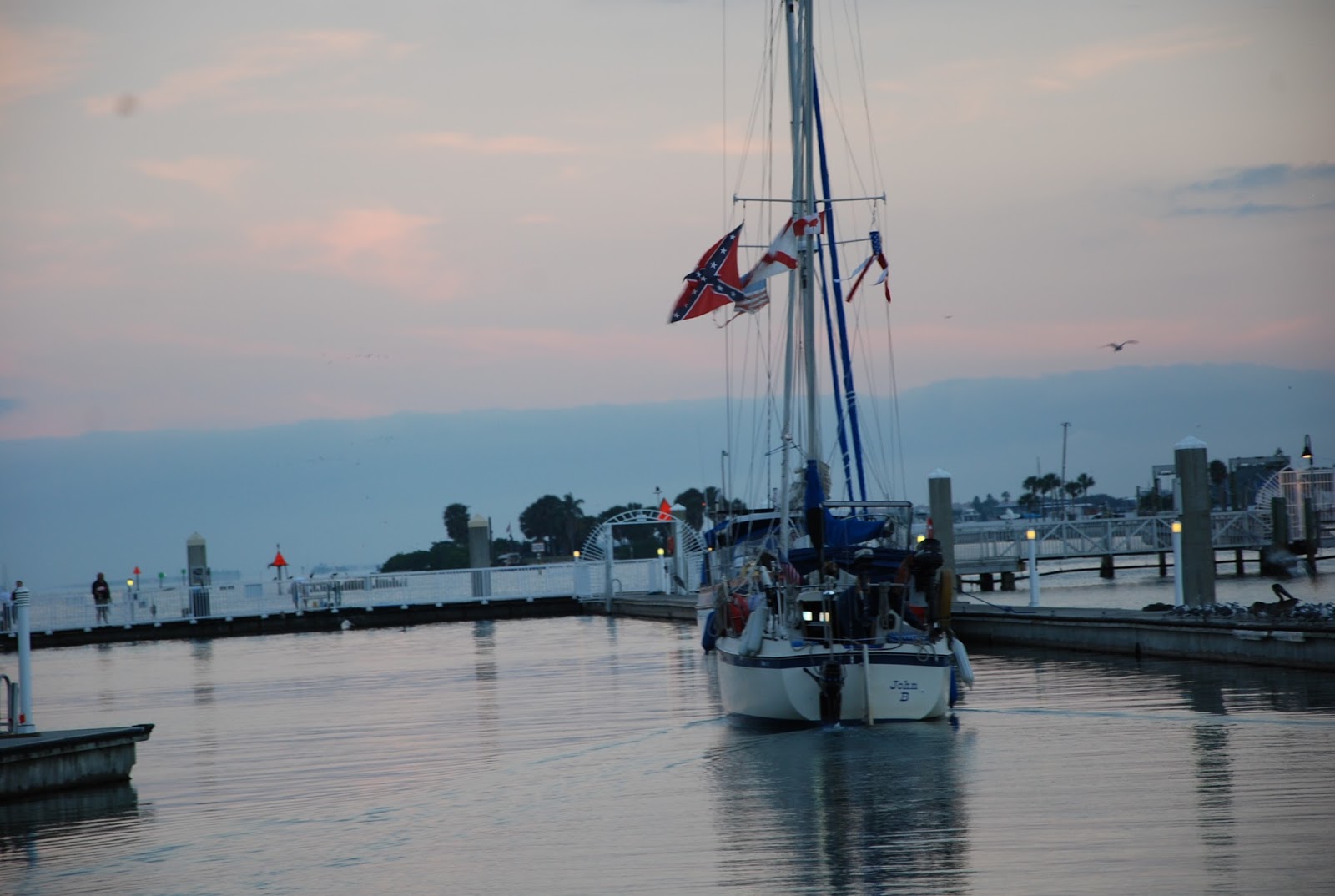
Thursday morning is sad for the 5 of us. Don on the sloop "John B" gets off first, headed to complete his loop. He is wanting to get across Tampa Bay and on to Fort Myers to start the Okeechobee crossing.
 |
| JOHN B HEADED FOR COMPLETION VIA the OKEECHOBEE |
Barb and I work on getting SummerTime ready to leave for St. Petersburg. At about 9am, we tell the crew, Chuck and Sue of "Somewhere in Time" good bye and they help us cast off. We are going different ways to Florida'a east coast. They are going to go slower, and cross the Okeechobee and the canals to and from it. Barbara and I are going down to the keys and go around to the east side. Some photos, tears, and parting words and we are off.
Our run to St Petersburg will be about 35 miles. Most of it will be on the Intracoastal Waterway. We discover, that even at 8 knots planned, it is going to take us longer than planned. There are a lot of slow, minimum, or no wake zones. Some of them are quite long, as the run down Indian Shores through what is labeled as "The Narrows" proves. Several miles at idle speed (way less than 8kt) ruins your ETA on the GPS display. We pass a McDonalds with a dinghy dock in one city.
 |
| DINGHY DOCK for McDONALDS at WELCH CAUSEWAY |
Total surprise. And a number of restaurants have piers or docks for patrons to come to dinner. Eventually we get to Tampa Bay on which we have a short run. It is not too rough, but the first few miles of the waterway are cut across a flat so your course has to be carefully watched to make sure you do not run aground.
 |
USCG VESSEL ON TAMPA BAY, IRONIC the RESCUE VESSEL IS NAMED
"DIAMONDBACK"
|
We get to the canal for Bayboro, and navigate to The Harborage Marina. It is at the end of the canal by the USF docks. It is a nice marina, and we are all tied up by 2:30. Our little boat is sitting with megayachts, the Azimuth in front of us is 110' long. I check bus schedules and call the St. Petersburg West Marine to see what charts they have. I hop a bus to their "flagship" store as they have the West Florida and Keys chartbook that I need. And I will pick up the East Florida chart book also while there. They had both books reserved for me when I got there. I added a few more items, and headed back to the bus stop. Probably the shortest time I have ever been in a West Marine store. I ride the bus back to the old town portion of St Petersburg and hike the last 9 blocks back to SummerTime rather than wait on the bus.
 |
| ST PETERSBURG SKYLINE |
Friday we had plans to go to museums and other attractions in the old town. But there is rain falling before we get up. And it rains off and on all morning. And the wind is up, so SummerTime is being rocked by the rollers coming down the channel off the bay. The rain clears out in the afternoon. Barbara and I can not get going soon enough to make the museums before they will close. We spend a quiet evening on the boat. I am looking at the new charts and trying to plan a route with possible stops to the keys. There is the long open water route from Marco Island to Key West, or the route along the west shore of Florida from South of Marco to Little Shark River to Marathon. I lean to make the run along the shore where refuge or help can be had if needed.


This is a great reference point for me as I read your blog. I know the marina, the museum, the tall buildings, the city of St. Petersburg. Deme has family in the area and I've grown somewhat aware of the location. So your blog feels extra-special and familiar. Still, I am nothing more than a mere land-lubber who is wetting his wings. Maybe I can travel with you on your upcoming adventures. Vic
ReplyDeleteWhat happens when you reach Point #67 on your journey? Is that the very end of your shipfaring travel? Do you dock the boat for the winter? What happens?
ReplyDelete